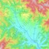
Topografische Karte Cortina
Klicken Sie auf die Karte, um die Höhe anzuzeigen.
Über diese Karte
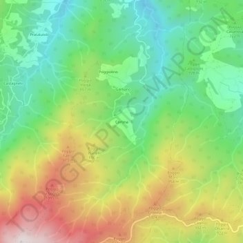
Name: Topografische Karte Cortina, Höhe, Relief.
Ort: Cortina, Castel San Niccolò, Arezzo, Tuscany, 52018, Italy (43.68703 11.66585 43.72703 11.70585)
Durchschnittliche Höhe: 771 m
Minimale Höhe: 443 m
Maximale Höhe: 1’273 m
Andere topografische Karten
Klicken Sie auf eine Karte, um ihre Topografie, ihre Höhe und ihr Relief anzuzeigen.
Cortona
The prevailing character of Cortona's architecture is medieval with steep narrow streets situated on a hillside at an elevation of 600 metres (2,000 ft) that embraces a view of the whole of the Valdichiana. From the Piazza Garibaldi (still referred to by the local population by its older name, Piazza…
Durchschnittliche Höhe: 375 m
Cortona
The prevailing character of Cortona's architecture is medieval with steep narrow streets situated on a hillside at an elevation of 600 metres (2,000 ft) that embraces a view of the whole of the Valdichiana. From the Piazza Garibaldi (still referred to by the local population by its older name, Piazza…
Durchschnittliche Höhe: 375 m
Cortona
The prevailing character of Cortona's architecture is medieval with steep narrow streets situated on a hillside at an elevation of 600 metres (2,000 ft) that embraces a view of the whole of the Valdichiana. From the Piazza Garibaldi (still referred to by the local population by its older name, Piazza…
Durchschnittliche Höhe: 375 m

Cortona
The prevailing character of Cortona's architecture is medieval with steep narrow streets situated on a hillside at an elevation of 600 metres (2,000 ft) that embraces a view of the whole of the Valdichiana. From the Piazza Garibaldi (still referred to by the local population by its older name, Piazza…
Durchschnittliche Höhe: 375 m