
Topografische Karte Cub Lake
Interaktive Karte
Klicken Sie auf die Karte, um die Höhe anzuzeigen.
Über diese Karte
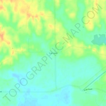
Name: Topografische Karte Cub Lake, Höhe, Relief.
Ort: Cub Lake, DeSoto County, Mississippi, United States (34.76649 -90.16926 34.80649 -90.12926)
Durchschnittliche Höhe: 71 m
Minimale Höhe: 57 m
Maximale Höhe: 92 m
Andere topografische Karten
Klicken Sie auf eine Karte, um ihre Topografie, ihre Höhe und ihr Relief anzuzeigen.
Lake Cormorant
United States > Mississippi > DeSoto County
Lake Cormorant, DeSoto County, Mississippi, United States
Durchschnittliche Höhe: 63 m
Maywood
United States > Mississippi > DeSoto County > Olive Branch
Maywood, Olive Branch, DeSoto County, Mississippi, 38654, United States
Durchschnittliche Höhe: 113 m
Olive Branch
United States > Mississippi > DeSoto County
Olive Branch, DeSoto County, Mississippi, 38654, United States
Durchschnittliche Höhe: 110 m
Nesbit
United States > Mississippi > DeSoto County > Hernando > Nesbit
Nesbit, Hernando, DeSoto County, Mississippi, 39651, United States
Durchschnittliche Höhe: 90 m
Hernando
United States > Mississippi > DeSoto County > Hernando > Hernando
Hernando, DeSoto County, Mississippi, 38632, United States
Durchschnittliche Höhe: 97 m
Hernando
United States > Mississippi > DeSoto County
Hernando, DeSoto County, Mississippi, United States
Durchschnittliche Höhe: 96 m
Southaven
United States > Mississippi > DeSoto County
Southaven, DeSoto County, Mississippi, United States
Durchschnittliche Höhe: 99 m