
Topografische Karte Douglas Pass
Interaktive Karte
Klicken Sie auf die Karte, um die Höhe anzuzeigen.
Über diese Karte
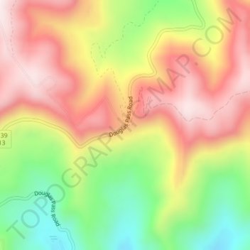
Name: Topografische Karte Douglas Pass, Höhe, Relief.
Ort: Douglas Pass, Garfield County, Colorado, United States (39.59766 -108.80499 39.59776 -108.80489)
Durchschnittliche Höhe: 2’435 m
Minimale Höhe: 2’137 m
Maximale Höhe: 2’694 m
Douglas Pass, elevation 8,205 feet (2,501 meters), is a mountain pass in the Book Cliffs of western Colorado. It is located in Garfield County and is traversed by State Highway 139. The pass divides the watersheds of West Douglas Creek to the north and East Salt Creek to the south. It is named for the Northern Ute, Chief Douglas.
Andere topografische Karten
Klicken Sie auf eine Karte, um ihre Topografie, ihre Höhe und ihr Relief anzuzeigen.
Glenwood Springs
United States > Colorado > Garfield County
Glenwood Springs, Garfield County, Colorado, 81601, United States
Durchschnittliche Höhe: 2’081 m
Battlement Mesa
United States > Colorado > Garfield County
Battlement Mesa, Garfield County, Colorado, 81635, United States
Durchschnittliche Höhe: 1’806 m
Carbondale
United States > Colorado > Garfield County
Carbondale, Garfield County, Colorado, United States
Durchschnittliche Höhe: 1’919 m
New Castle
United States > Colorado > Garfield County
New Castle, Garfield County, Colorado, 81647, United States
Durchschnittliche Höhe: 1’810 m
Rifle
United States > Colorado > Garfield County
Rifle, Garfield County, Colorado, 81650, United States
Durchschnittliche Höhe: 1’731 m