
Topografische Karte Jefferson
Interaktive Karte
Klicken Sie auf die Karte, um die Höhe anzuzeigen.
Über diese Karte
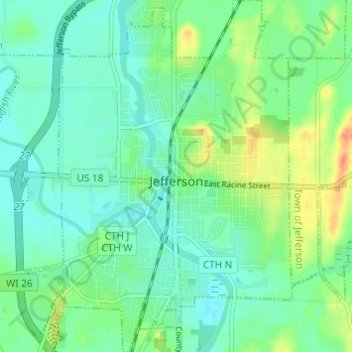
Name: Topografische Karte Jefferson, Höhe, Relief.
Ort: Jefferson, Jefferson County, Wisconsin, 53549, United States (42.98380 -88.83506 43.02834 -88.77636)
Durchschnittliche Höhe: 251 m
Minimale Höhe: 236 m
Maximale Höhe: 285 m
Jefferson's elevation is 797 ft (243 m) at the center of downtown.
Andere topografische Karten
Klicken Sie auf eine Karte, um ihre Topografie, ihre Höhe und ihr Relief anzuzeigen.
Lake Koshkonong
United States > Wisconsin > Jefferson County > Town of Koshkonong
Lake Koshkonong, Town of Koshkonong, Town of Sumner, Jefferson County, Wisconsin, United States
Durchschnittliche Höhe: 244 m
Lake Ripley
United States > Wisconsin > Jefferson County
Lake Ripley, Jefferson County, Wisconsin, United States
Durchschnittliche Höhe: 262 m
Town of Watertown
United States > Wisconsin > Jefferson County
Town of Watertown, Jefferson County, Wisconsin, United States
Durchschnittliche Höhe: 260 m
Kettle Moraine State Forest - South
United States > Wisconsin > Jefferson County
Kettle Moraine State Forest - South, Town of Palmyra, Jefferson County, Wisconsin, 53501, United States
Durchschnittliche Höhe: 274 m
Sullivan
United States > Wisconsin > Jefferson County
Sullivan, Jefferson County, Wisconsin, 53178, United States
Durchschnittliche Höhe: 262 m
Hebron
United States > Wisconsin > Jefferson County
Hebron, Town of Hebron, Jefferson County, Wisconsin, United States
Durchschnittliche Höhe: 251 m
Lake Mills
United States > Wisconsin > Jefferson County
Lake Mills, Jefferson County, Wisconsin, 53551, United States
Durchschnittliche Höhe: 256 m
Ixonia
United States > Wisconsin > Jefferson County > Ixonia
Ixonia, Town of Ixonia, Jefferson County, Wisconsin, United States
Durchschnittliche Höhe: 261 m
Town of Koshkonong
United States > Wisconsin > Jefferson County
Town of Koshkonong, Jefferson County, Wisconsin, 53538, United States
Durchschnittliche Höhe: 251 m
Palmyra
United States > Wisconsin > Jefferson County
Palmyra, Jefferson County, Wisconsin, 53156, United States
Durchschnittliche Höhe: 258 m
Town of Jefferson
United States > Wisconsin > Jefferson County
Town of Jefferson, Jefferson County, Wisconsin, 53137, United States
Durchschnittliche Höhe: 252 m
Watertown
United States > Wisconsin > Jefferson County
Watertown, Jefferson County, Wisconsin, 53094, United States
Durchschnittliche Höhe: 258 m
Town of Farmington
United States > Wisconsin > Jefferson County
Town of Farmington, Jefferson County, Wisconsin, United States
Durchschnittliche Höhe: 260 m
Town of Sullivan
United States > Wisconsin > Jefferson County
Town of Sullivan, Jefferson County, Wisconsin, United States
Durchschnittliche Höhe: 261 m
Town of Aztalan
United States > Wisconsin > Jefferson County
Town of Aztalan, Jefferson County, Wisconsin, United States
Durchschnittliche Höhe: 253 m
Rome
United States > Wisconsin > Jefferson County > Rome
Rome, Town of Sullivan, Jefferson County, Wisconsin, United States
Durchschnittliche Höhe: 258 m
Town of Milford
United States > Wisconsin > Jefferson County
Town of Milford, Jefferson County, Wisconsin, United States
Durchschnittliche Höhe: 249 m
Town of Oakland
United States > Wisconsin > Jefferson County
Town of Oakland, Jefferson County, Wisconsin, United States
Durchschnittliche Höhe: 266 m
Waterloo
United States > Wisconsin > Jefferson County
Waterloo, Jefferson County, Wisconsin, 53594, United States
Durchschnittliche Höhe: 257 m
Fort Atkinson
United States > Wisconsin > Jefferson County
Fort Atkinson, Jefferson County, Wisconsin, United States
Durchschnittliche Höhe: 249 m
Johnson Creek
United States > Wisconsin > Jefferson County
Johnson Creek, Jefferson County, Wisconsin, 53038, United States
Durchschnittliche Höhe: 249 m
Aztalan State Park
United States > Wisconsin > Jefferson County > Town of Aztalan
Aztalan State Park, Town of Aztalan, Jefferson County, Wisconsin, United States
Durchschnittliche Höhe: 255 m