
Topografische Karte Jaintia Hills
Interaktive Karte
Klicken Sie auf die Karte, um die Höhe anzuzeigen.
Über diese Karte
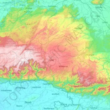
Name: Topografische Karte Jaintia Hills, Höhe, Relief.
Ort: Jaintia Hills, West Jaintia Hills, Meghalaya, India (24.80000 91.55000 26.20000 92.95000)
Durchschnittliche Höhe: 534 m
Minimale Höhe: 4 m
Maximale Höhe: 1’948 m
Andere topografische Karten
Klicken Sie auf eine Karte, um ihre Topografie, ihre Höhe und ihr Relief anzuzeigen.
Riwai Village
India > Meghalaya > Pynursla > Nohwet Village
Riwai Village, Nohwet Village, Pynursla, East Khasi Hills District, Meghalaya, India
Durchschnittliche Höhe: 430 m
river
India > Meghalaya > Shella Bholaganj
river, Shella Bholaganj, East Khasi Hills District, Meghalaya, India
Durchschnittliche Höhe: 437 m
Pyndem Mawthawiong
Pyndem Mawthawiong, Mawkyrwat, South West Khasi Hills District, Meghalaya, India
Durchschnittliche Höhe: 1’573 m
Umiew
India > Meghalaya > Khatarshnong Laitkroh > Smit
Umiew, Smit, Khatarshnong Laitkroh, East Khasi Hills District, Meghalaya, India
Durchschnittliche Höhe: 1’712 m
Sohsarat
India > Meghalaya > Shella Bholaganj > Nongwar
Sohsarat, Nongwar, Shella Bholaganj, East Khasi Hills District, Meghalaya, India
Durchschnittliche Höhe: 372 m
Mawthadraishan
Mawthadraishan, Eastern West Khasi Hills District, Meghalaya, India
Durchschnittliche Höhe: 1’523 m
River Umiam
River Umiam, Sohiong, East Khasi Hills District, Meghalaya, India
Durchschnittliche Höhe: 1’440 m
Khasi Hills
India > Meghalaya > Mawshynrut
Khasi Hills, Mawshynrut, West Khasi Hills District, Meghalaya, India
Durchschnittliche Höhe: 349 m
Nongthymmai
India > Meghalaya > Shella Bholaganj
Nongthymmai, Shella Bholaganj, East Khasi Hills District, Meghalaya, 793108, India
Durchschnittliche Höhe: 1’123 m
Sohra (Cherrapunji)
India > Meghalaya > Shella Bholaganj
Sohra (Cherrapunji), Shella Bholaganj, East Khasi Hills District, Meghalaya, 793108, India
Durchschnittliche Höhe: 1’169 m
Suktia
India > Meghalaya > Shella Bholaganj
Suktia, Shella Bholaganj, East Khasi Hills, Meghalaya, India
Durchschnittliche Höhe: 486 m
Thadlaskein
Thadlaskein, West Jaintia Hills, Meghalaya, 793151, India
Durchschnittliche Höhe: 1’135 m
Elephant Falls
Elephant Falls, Sohiong, East Khasi Hills, Meghalaya, India
Durchschnittliche Höhe: 1’724 m
Shella Bholaganj
Shella Bholaganj, East Khasi Hills District, Meghalaya, India
Durchschnittliche Höhe: 764 m
Nohsngithiang Falls (Seven Sisters)
India > Meghalaya > Shella Bholaganj
Nohsngithiang Falls (Seven Sisters), Shella Bholaganj, East Khasi Hills, Meghalaya, 793108, India
Durchschnittliche Höhe: 1’043 m
Umiam Lake
India > Meghalaya > Umsning > Sumer Village
Umiam Lake, Sumer Village, Umsning, Ri-Bhoi District, Meghalaya, India
Durchschnittliche Höhe: 1’058 m
Khliehriat
Khliehriat, East Jaintia Hills District, Meghalaya, India
Durchschnittliche Höhe: 717 m
South West Garo Hills
South West Garo Hills, Meghalaya, India
Durchschnittliche Höhe: 83 m
Bapung
India > Meghalaya > Jaintia Hills > Bapung
Bapung, Jaintia Hills, West Jaintia Hills, Meghalaya, India
Durchschnittliche Höhe: 1’305 m
South West Khasi Hills
South West Khasi Hills, Meghalaya, India
Durchschnittliche Höhe: 756 m
North Garo Hills District
North Garo Hills District, Meghalaya, India
Durchschnittliche Höhe: 251 m
Resubelpara
Resubelpara, North Garo Hills, Meghalaya, India
Durchschnittliche Höhe: 163 m
Lad Rymbai
India > Meghalaya > Lad Rymbai
Lad Rymbai, Khliehriat, East Jaintia Hills, Meghalaya, 793200, India
Durchschnittliche Höhe: 1’225 m
Umiam River
Umiam River, Umsning, Ri-Bhoi, Meghalaya, 793103, India
Durchschnittliche Höhe: 924 m