
Topografische Karte Honea Path
Interaktive Karte
Klicken Sie auf die Karte, um die Höhe anzuzeigen.
Über diese Karte
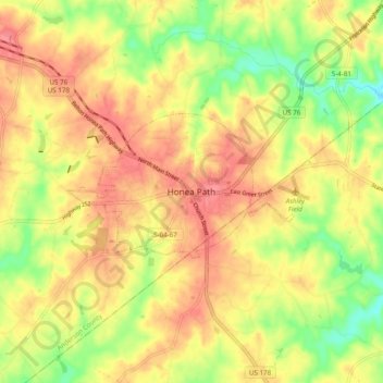
Name: Topografische Karte Honea Path, Höhe, Relief.
Durchschnittliche Höhe: 223 m
Minimale Höhe: 183 m
Maximale Höhe: 252 m
Andere topografische Karten
Klicken Sie auf eine Karte, um ihre Topografie, ihre Höhe und ihr Relief anzuzeigen.
Piedmont
United States > South Carolina > Anderson County > Piedmont
Piedmont, Anderson County, South Carolina, United States
Durchschnittliche Höhe: 257 m
Quail Hollow
United States > South Carolina > Anderson County
Quail Hollow, Anderson County, South Carolina, 19621, United States
Durchschnittliche Höhe: 229 m
Allen Hills
United States > South Carolina > Anderson County > Anderson
Allen Hills, Anderson, Anderson County, South Carolina, 29621, United States
Durchschnittliche Höhe: 229 m
Starr
United States > South Carolina > Anderson County
Starr, Anderson County, South Carolina, United States
Durchschnittliche Höhe: 227 m
Warley Woods
United States > South Carolina > Anderson County > Pendleton
Warley Woods, Pendleton, Anderson County, South Carolina, 29670, United States
Durchschnittliche Höhe: 246 m