
Spenden
Rüste dich für dein nächstes Abenteuer:
Als Amazon-Partner verdient diese Seite an qualifizierten Käufen, ohne dass Ihnen zusätzliche Kosten entstehen.
Topografische Karte The Notch
Klicken Sie auf die Karte, um die Höhe anzuzeigen.
Spenden
Rüste dich für dein nächstes Abenteuer:
Als Amazon-Partner verdient diese Seite an qualifizierten Käufen, ohne dass Ihnen zusätzliche Kosten entstehen.
Über diese Karte
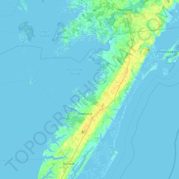
Name: Topografische Karte The Notch, Höhe, Relief.
Ort: The Notch, Accomack County, Virginia, United States (37.47652 -76.04771 38.11652 -75.40771)
Durchschnittliche Höhe: 2 m
Minimale Höhe: -5 m
Maximale Höhe: 21 m
Spenden
Rüste dich für dein nächstes Abenteuer:
Als Amazon-Partner verdient diese Seite an qualifizierten Käufen, ohne dass Ihnen zusätzliche Kosten entstehen.
Andere topografische Karten
Klicken Sie auf eine Karte, um ihre Topografie, ihre Höhe und ihr Relief anzuzeigen.
Chincoteague
United States > Virginia > Accomack County
Chincoteague is located at 37°56′5″N 75°22′4″W / 37.93472°N 75.36778°W / 37.93472; -75.36778 (37.934673, −75.367805). According to the United States Census Bureau, the town has a total area of 37.3 square miles (96.7 km2), of which 9.1 square miles (23.6 km2) is land and 28.2 square…
Durchschnittliche Höhe: 1 m
Spenden
Rüste dich für dein nächstes Abenteuer:
Als Amazon-Partner verdient diese Seite an qualifizierten Käufen, ohne dass Ihnen zusätzliche Kosten entstehen.
Onancock
United States > Virginia > Accomack County
It lies at an elevation of 16 feet, and is on the Eastern Shore of Virginia.
Durchschnittliche Höhe: 6 m
Spenden
Rüste dich für dein nächstes Abenteuer:
Als Amazon-Partner verdient diese Seite an qualifizierten Käufen, ohne dass Ihnen zusätzliche Kosten entstehen.
Onley
United States > Virginia > Accomack County
It lies at an elevation of 43 feet.
Durchschnittliche Höhe: 14 m
Onancock
United States > Virginia > Accomack County
It lies at an elevation of 16 feet.
Durchschnittliche Höhe: 6 m
Spenden
Rüste dich für dein nächstes Abenteuer:
Als Amazon-Partner verdient diese Seite an qualifizierten Käufen, ohne dass Ihnen zusätzliche Kosten entstehen.