
Topografische Karte Town of Newfield
Interaktive Karte
Klicken Sie auf die Karte, um die Höhe anzuzeigen.
Über diese Karte
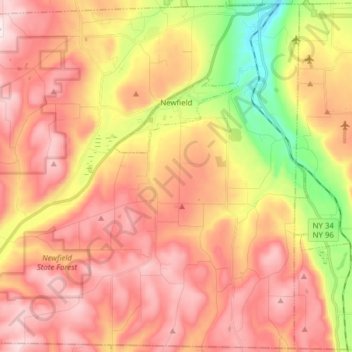
Name: Topografische Karte Town of Newfield, Höhe, Relief.
Durchschnittliche Höhe: 426 m
Minimale Höhe: 134 m
Maximale Höhe: 634 m
Andere topografische Karten
Klicken Sie auf eine Karte, um ihre Topografie, ihre Höhe und ihr Relief anzuzeigen.
Town of Danby
United States > New York > Tompkins County
Town of Danby, Tompkins County, New York, United States
Durchschnittliche Höhe: 404 m
City of Ithaca
United States > New York > Tompkins County
City of Ithaca, Tompkins County, New York, United States
Durchschnittliche Höhe: 195 m
Buttermilk Falls State Park
United States > New York > Tompkins County > Ithaca > Town of Danby
Buttermilk Falls State Park, Ithaca, Town of Danby, Tompkins County, New York, United States
Durchschnittliche Höhe: 269 m
East Ithaca
United States > New York > Tompkins County > Ithaca > East Ithaca
East Ithaca, Ithaca, Tompkins County, New York, United States
Durchschnittliche Höhe: 281 m
Town of Ithaca
United States > New York > Tompkins County
Town of Ithaca, Tompkins County, New York, United States
Durchschnittliche Höhe: 288 m
Town of Dryden
United States > New York > Tompkins County
Town of Dryden, Tompkins County, New York, United States
Durchschnittliche Höhe: 430 m
Waterburg
United States > New York > Tompkins County > Waterburg
Waterburg, Ulysses Town, Tompkins County, New York, 14886, United States
Durchschnittliche Höhe: 318 m