
Topografische Karte Kenichira
Interaktive Karte
Klicken Sie auf die Karte, um die Höhe anzuzeigen.
Über diese Karte
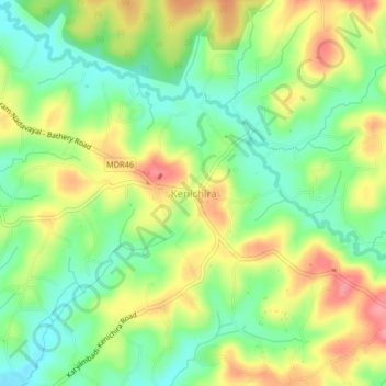
Name: Topografische Karte Kenichira, Höhe, Relief.
Durchschnittliche Höhe: 770 m
Minimale Höhe: 731 m
Maximale Höhe: 818 m
Andere topografische Karten
Klicken Sie auf eine Karte, um ihre Topografie, ihre Höhe und ihr Relief anzuzeigen.
Kuruva Island
India > Kerala > Sulthanbathery
Kuruva Island, Sulthanbathery, Wayanad District, Kerala, India
Durchschnittliche Höhe: 733 m
Nambikolly
India > Kerala > Sulthanbathery
Nambikolly, Sulthanbathery, Wayanad, Kerala, 673595, India
Durchschnittliche Höhe: 873 m
Ambalavayal
India > Kerala > Sulthanbathery > Ambalavayal
Ambalavayal, Sulthanbathery, Wayanad, Kerala, 673593, India
Durchschnittliche Höhe: 880 m
Meenangadi
India > Kerala > Sulthanbathery > Meenangadi
Meenangadi, Sulthanbathery, Wayanad, Kerala, 673591, India
Durchschnittliche Höhe: 785 m
Sulthanbathery
India > Kerala > Sulthanbathery
Sulthanbathery, Wayanad, Kerala, India
Durchschnittliche Höhe: 836 m