
Topografische Karte Morgantown
Interaktive Karte
Klicken Sie auf die Karte, um die Höhe anzuzeigen.
Über diese Karte
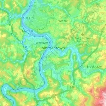
Name: Topografische Karte Morgantown, Höhe, Relief.
Ort: Morgantown, Monongalia County, West Virginia, United States (39.57431 -79.98816 39.67510 -79.89877)
Durchschnittliche Höhe: 337 m
Minimale Höhe: 241 m
Maximale Höhe: 581 m
During the 1970s, the U.S. Department of Transportation built an experimental driverless personal rapid transit system in the city, citing the area's variable seasonal climate and geographic elevations as factors in testing the technology's viability. The Morgantown Personal Rapid Transit (PRT) has been in use since 1975. University students use the system for free travel between the campuses.
Andere topografische Karten
Klicken Sie auf eine Karte, um ihre Topografie, ihre Höhe und ihr Relief anzuzeigen.
Bula
United States > West Virginia > Monongalia County > Bula
Bula, Monongalia County, West Virginia, 26521, United States
Durchschnittliche Höhe: 360 m
Monongalia County
United States > West Virginia > Monongalia County
Monongalia County, West Virginia, United States
Durchschnittliche Höhe: 418 m