
Topografische Karte Fort Thomas
Interaktive Karte
Klicken Sie auf die Karte, um die Höhe anzuzeigen.
Über diese Karte
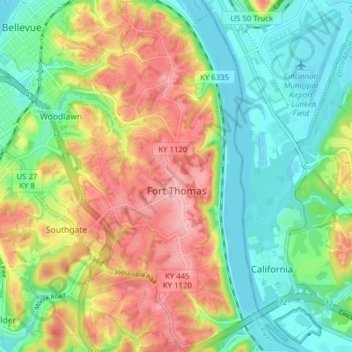
Name: Topografische Karte Fort Thomas, Höhe, Relief.
Ort: Fort Thomas, Campbell County, Kentucky, 41075, United States (39.05088 -84.47307 39.11133 -84.42890)
Durchschnittliche Höhe: 192 m
Minimale Höhe: 140 m
Maximale Höhe: 265 m
Andere topografische Karten
Klicken Sie auf eine Karte, um ihre Topografie, ihre Höhe und ihr Relief anzuzeigen.
Newport
United States > Kentucky > Campbell County
Newport, Campbell County, Kentucky, 41071, United States
Durchschnittliche Höhe: 173 m
Dayton
United States > Kentucky > Campbell County
Dayton, Campbell County, Kentucky, 41074, United States
Durchschnittliche Höhe: 190 m
Melbourne
United States > Kentucky > Campbell County
Melbourne, Campbell County, Kentucky, United States
Durchschnittliche Höhe: 168 m
Alexandria
United States > Kentucky > Campbell County
Alexandria, Campbell County, Kentucky, United States
Durchschnittliche Höhe: 220 m
Newport
United States > Kentucky > Campbell County > Newport
Newport, Campbell County, Kentucky, 41071-9998, United States
Durchschnittliche Höhe: 195 m
Cold Spring
United States > Kentucky > Campbell County
Cold Spring, Campbell County, Kentucky, 41076, United States
Durchschnittliche Höhe: 211 m
Wilder
United States > Kentucky > Campbell County
Wilder, Campbell County, Kentucky, United States
Durchschnittliche Höhe: 207 m
Highland Heights
United States > Kentucky > Campbell County
Highland Heights, Campbell County, Kentucky, 41099, United States
Durchschnittliche Höhe: 237 m