
Spenden
Rüste dich für dein nächstes Abenteuer:
Als Amazon-Partner verdient diese Seite an qualifizierten Käufen, ohne dass Ihnen zusätzliche Kosten entstehen.
Topografische Karte Bowman Lake
Klicken Sie auf die Karte, um die Höhe anzuzeigen.
Spenden
Rüste dich für dein nächstes Abenteuer:
Als Amazon-Partner verdient diese Seite an qualifizierten Käufen, ohne dass Ihnen zusätzliche Kosten entstehen.
Über diese Karte
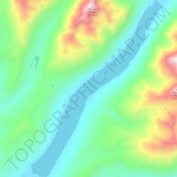
Name: Topografische Karte Bowman Lake, Höhe, Relief.
Ort: Bowman Lake, Flathead County, Montana, United States (48.82808 -114.20205 48.90613 -114.11482)
Durchschnittliche Höhe: 1’639 m
Minimale Höhe: 1’223 m
Maximale Höhe: 2’736 m
Spenden
Rüste dich für dein nächstes Abenteuer:
Als Amazon-Partner verdient diese Seite an qualifizierten Käufen, ohne dass Ihnen zusätzliche Kosten entstehen.
Andere topografische Karten
Klicken Sie auf eine Karte, um ihre Topografie, ihre Höhe und ihr Relief anzuzeigen.
West Glacier
United States > Montana > Flathead County
The community, heavily dependent on tourism, has a small permanent population that expands significantly during the summer tourist season; most area businesses are likewise seasonal—including the 18-hole golf course—and are primarily geared towards travelers. The elevation is 3,169 feet (966 m).
Durchschnittliche Höhe: 1’201 m
Kalispell
United States > Montana > Flathead County
Kalispell is located at 48°11′52″N 114°18′58″W / 48.19778°N 114.31611°W / 48.19778; -114.31611 (48.197801, −114.316068), at an elevation of 2,956 feet (901 m).
Durchschnittliche Höhe: 934 m
Spenden
Rüste dich für dein nächstes Abenteuer:
Als Amazon-Partner verdient diese Seite an qualifizierten Käufen, ohne dass Ihnen zusätzliche Kosten entstehen.
Spenden
Rüste dich für dein nächstes Abenteuer:
Als Amazon-Partner verdient diese Seite an qualifizierten Käufen, ohne dass Ihnen zusätzliche Kosten entstehen.
Spenden
Rüste dich für dein nächstes Abenteuer:
Als Amazon-Partner verdient diese Seite an qualifizierten Käufen, ohne dass Ihnen zusätzliche Kosten entstehen.
Spenden
Rüste dich für dein nächstes Abenteuer:
Als Amazon-Partner verdient diese Seite an qualifizierten Käufen, ohne dass Ihnen zusätzliche Kosten entstehen.
Spenden
Rüste dich für dein nächstes Abenteuer:
Als Amazon-Partner verdient diese Seite an qualifizierten Käufen, ohne dass Ihnen zusätzliche Kosten entstehen.
Kalispell
United States > Montana > Flathead County
Kalispell is located at 48°11′52″N 114°18′58″W / 48.19778°N 114.31611°W / 48.19778; -114.31611 (48.197801, −114.316068), at an elevation of 2,956 feet (901 m).
Durchschnittliche Höhe: 934 m
Spenden
Rüste dich für dein nächstes Abenteuer:
Als Amazon-Partner verdient diese Seite an qualifizierten Käufen, ohne dass Ihnen zusätzliche Kosten entstehen.
Vulture Glacier
United States > Montana > Flathead County
Vulture Glacier is in Glacier National Park, U.S. state of Montana. The glacier is situated just south of Vulture Peak at an average elevation of 8,412 feet (2,564 m) above sea level. Between 1966 and 2005, Vulture Glacier lost over 50 percent of its surface area.
Durchschnittliche Höhe: 2’392 m
Spenden
Rüste dich für dein nächstes Abenteuer:
Als Amazon-Partner verdient diese Seite an qualifizierten Käufen, ohne dass Ihnen zusätzliche Kosten entstehen.
Spenden
Rüste dich für dein nächstes Abenteuer:
Als Amazon-Partner verdient diese Seite an qualifizierten Käufen, ohne dass Ihnen zusätzliche Kosten entstehen.
Spenden
Rüste dich für dein nächstes Abenteuer:
Als Amazon-Partner verdient diese Seite an qualifizierten Käufen, ohne dass Ihnen zusätzliche Kosten entstehen.
Kalispell
United States > Montana > Flathead County
Kalispell is located at 48°11′52″N 114°18′58″W / 48.19778°N 114.31611°W / 48.19778; -114.31611 (48.197801, −114.316068), at an elevation of 2,956 feet (901 m).
Durchschnittliche Höhe: 934 m
Kalispell
United States > Montana > Flathead County > Kalispell
Kalispell is located at 48°11′52″N 114°18′58″W / 48.19778°N 114.31611°W / 48.19778; -114.31611 (48.197801, −114.316068), at an elevation of 2,956 feet (901 m).
Durchschnittliche Höhe: 1’055 m
Spenden
Rüste dich für dein nächstes Abenteuer:
Als Amazon-Partner verdient diese Seite an qualifizierten Käufen, ohne dass Ihnen zusätzliche Kosten entstehen.