
Spenden
Rüste dich für dein nächstes Abenteuer:
Als Amazon-Partner verdient diese Seite an qualifizierten Käufen, ohne dass Ihnen zusätzliche Kosten entstehen.
Topografische Karte Moline
Klicken Sie auf die Karte, um die Höhe anzuzeigen.
Spenden
Rüste dich für dein nächstes Abenteuer:
Als Amazon-Partner verdient diese Seite an qualifizierten Käufen, ohne dass Ihnen zusätzliche Kosten entstehen.
Moline
Moline witnessed a continued population increase after World War II with the completion of "Molette", a subdivision of mass-produced starter homes selling for $5,000 each. Molette was the first Moline neighborhood produced on a mass scale and one of the largest single-unit housing projects in the Midwest at the time. Near Molette on 41st Street, the Defense Department funded an $800,000 housing project known as Springbrook Courts, which served as housing for Rock Island Arsenal employees before being converted into a non-military-affiliated public housing project managed by the Moline Housing Authority. It was in this time that one of the major factors shaping the modern layout of Moline first came into play—the rough topography of the inland bluffs. As Moline grew, the traditional rectilinear grid of the downtown area gave way to smaller subdivisions containing cul-de-sacs, curvilinear roadways, and courts. As a comprehensive plan of Moline later stated, "the topography has had a decided influence upon the growth and development of the city . . . the city is literally interlaced with fingers of wooded ravines draining surface water to the north into the Mississippi and to the south into the creeks and drainage ditches tributary to the Rock River. This condition has greatly influenced the building of underground utilities, the location of thoroughfares, the selection of sites for schools and parks, the design and development of residential areas, and the location of business and industrial areas. The customary ‘grid’ type subdivision planning so common to most Midwestern cities is impractical of adaptation when looking at a map of the present city. Some streets . . . have been dedicated but never improved because of the topography and the excessive cost of construction."
Spenden
Rüste dich für dein nächstes Abenteuer:
Als Amazon-Partner verdient diese Seite an qualifizierten Käufen, ohne dass Ihnen zusätzliche Kosten entstehen.
Über diese Karte
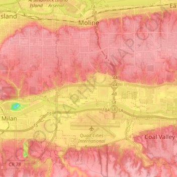
Name: Topografische Karte Moline, Höhe, Relief.
Ort: Moline, Rock Island County, Illinois, 61265, United States (41.42098 -90.53941 41.51832 -90.43210)
Durchschnittliche Höhe: 193 m
Minimale Höhe: 105 m
Maximale Höhe: 225 m
Spenden
Rüste dich für dein nächstes Abenteuer:
Als Amazon-Partner verdient diese Seite an qualifizierten Käufen, ohne dass Ihnen zusätzliche Kosten entstehen.
Andere topografische Karten
Klicken Sie auf eine Karte, um ihre Topografie, ihre Höhe und ihr Relief anzuzeigen.
Mel McKay Park
United States > Illinois > Rock Island County > Rock Island
Durchschnittliche Höhe: 200 m