
Topografische Karte St. Helier
Interaktive Karte
Klicken Sie auf die Karte, um die Höhe anzuzeigen.
Über diese Karte
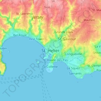
Name: Topografische Karte St. Helier, Höhe, Relief.
Ort: St. Helier, JE4 8PA, Jersey (49.14566 -2.15023 49.22566 -2.07023)
Durchschnittliche Höhe: 32 m
Minimale Höhe: -2 m
Maximale Höhe: 108 m
The topography of the parish is one of the most varied. The marshland on which the town is situated is encircled by highlands which protect the town from the worst winds. In the southeast of the parish, rising from the plains in the centre of town, there is also Mont de Ville. This divides the Havre des Pas district from the Harbour.