
Spenden
Rüste dich für dein nächstes Abenteuer:
Als Amazon-Partner verdient diese Seite an qualifizierten Käufen, ohne dass Ihnen zusätzliche Kosten entstehen.
Topografische Karte Ocoee River
Klicken Sie auf die Karte, um die Höhe anzuzeigen.
Spenden
Rüste dich für dein nächstes Abenteuer:
Als Amazon-Partner verdient diese Seite an qualifizierten Käufen, ohne dass Ihnen zusätzliche Kosten entstehen.
Über diese Karte
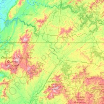
Name: Topografische Karte Ocoee River, Höhe, Relief.
Durchschnittliche Höhe: 579 m
Minimale Höhe: 214 m
Maximale Höhe: 1’269 m
Spenden
Rüste dich für dein nächstes Abenteuer:
Als Amazon-Partner verdient diese Seite an qualifizierten Käufen, ohne dass Ihnen zusätzliche Kosten entstehen.
Andere topografische Karten
Klicken Sie auf eine Karte, um ihre Topografie, ihre Höhe und ihr Relief anzuzeigen.
Spenden
Rüste dich für dein nächstes Abenteuer:
Als Amazon-Partner verdient diese Seite an qualifizierten Käufen, ohne dass Ihnen zusätzliche Kosten entstehen.
Cohutta Wildlife Management Area
United States > Georgia > Fannin County
Durchschnittliche Höhe: 653 m
Springer Mountain
United States > Georgia > Fannin County
Springer Mountain is a mountain located in the Chattahoochee National Forest on the border of Fannin and Gilmer counties. Located in the Blue Ridge Mountains in northern Georgia, the mountain has an elevation of about 3,782 feet (1,153 m). Springer Mountain serves as the southern terminus for the Appalachian…
Durchschnittliche Höhe: 941 m
Spenden
Rüste dich für dein nächstes Abenteuer:
Als Amazon-Partner verdient diese Seite an qualifizierten Käufen, ohne dass Ihnen zusätzliche Kosten entstehen.
Spenden
Rüste dich für dein nächstes Abenteuer:
Als Amazon-Partner verdient diese Seite an qualifizierten Käufen, ohne dass Ihnen zusätzliche Kosten entstehen.
Morgantown Baptist Association Dam
United States > Georgia > Fannin County
Durchschnittliche Höhe: 650 m
Spenden
Rüste dich für dein nächstes Abenteuer:
Als Amazon-Partner verdient diese Seite an qualifizierten Käufen, ohne dass Ihnen zusätzliche Kosten entstehen.
Springer Mountain
United States > Georgia > Fannin County
Springer Mountain is a mountain located in the Chattahoochee National Forest on the border of Fannin and Gilmer counties. Located in the Blue Ridge Mountains in northern Georgia, the mountain has an elevation of about 3,782 feet (1,153 m). Springer Mountain serves as the southern terminus for the Appalachian…
Durchschnittliche Höhe: 941 m