
Spenden
Rüste dich für dein nächstes Abenteuer:
Als Amazon-Partner verdient diese Seite an qualifizierten Käufen, ohne dass Ihnen zusätzliche Kosten entstehen.
Topografische Karte Hudson River
Klicken Sie auf die Karte, um die Höhe anzuzeigen.
Spenden
Rüste dich für dein nächstes Abenteuer:
Als Amazon-Partner verdient diese Seite an qualifizierten Käufen, ohne dass Ihnen zusätzliche Kosten entstehen.
Hudson River
The source of the Hudson River is Lake Tear of the Clouds in the Adirondack Park at an elevation of 4,322 feet (1,317 m). However, the river is not cartographically called the Hudson River until miles downstream. The river is named Feldspar Brook until its confluence with the Opalescent River, and then is named the Opalescent River until the river reaches Calamity Brook, flowing south from the outlet of Henderson Lake. From that point on, the stream is cartographically known as the Hudson River. The U.S. Geological Survey (USGS) uses this cartographical definition.
Spenden
Rüste dich für dein nächstes Abenteuer:
Als Amazon-Partner verdient diese Seite an qualifizierten Käufen, ohne dass Ihnen zusätzliche Kosten entstehen.
Über diese Karte
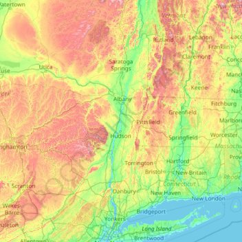
Name: Topografische Karte Hudson River, Höhe, Relief.
Ort: Hudson River, New York, United States (40.69994 -74.19885 44.09098 -73.57319)
Durchschnittliche Höhe: 301 m
Minimale Höhe: -2 m
Maximale Höhe: 1’384 m
Spenden
Rüste dich für dein nächstes Abenteuer:
Als Amazon-Partner verdient diese Seite an qualifizierten Käufen, ohne dass Ihnen zusätzliche Kosten entstehen.
Andere topografische Karten
Klicken Sie auf eine Karte, um ihre Topografie, ihre Höhe und ihr Relief anzuzeigen.
Central Park
United States > New York > New York County > New York
In June 1856, Fernando Wood appointed a "consulting board" of seven people, headed by author Washington Irving, to inspire public confidence in the proposed development. Wood hired military engineer Egbert Ludovicus Viele as the park's chief engineer, tasking him with a topographical survey of the site. The…
Durchschnittliche Höhe: 26 m
Smithtown Pines
United States > New York > Suffolk County > Town of Smithtown
Durchschnittliche Höhe: 29 m
Spenden
Rüste dich für dein nächstes Abenteuer:
Als Amazon-Partner verdient diese Seite an qualifizierten Käufen, ohne dass Ihnen zusätzliche Kosten entstehen.
Tug Hill
United States > New York > Oswego County
The core Tug Hill region encompasses 150,000 acres (610 km2) of unbroken, generally second-growth, northern hardwood forest, and is drained by a vast network of streams. Important rivers and streams whose headwaters are located within the Tug Hill region include the Mohawk River, Deer River, Salmon River, Mad…
Durchschnittliche Höhe: 109 m
Riverside Park
United States > New York > New York County > New York
Initially, Riverside Avenue had been planned to run in a straight line, which would have required a retaining wall and extensive fill. However, the area's difficult topography had come to the attention of the Manhattan park commissioners. In 1873, the commissioners selected Frederick Law Olmsted, a park…
Durchschnittliche Höhe: 17 m
Mount Marcy
United States > New York > Essex County > Town of Keene
Mount Marcy is the highest point in the Adirondack Mountains and the U.S. state of New York, with an elevation of 5,343.1 feet (1,628.6 m). It is located in the town of Keene in Essex County. The mountain is in the heart of the High Peaks Wilderness Area in Adirondack Park. Like the surrounding Adirondack…
Durchschnittliche Höhe: 1’289 m
Central Park
United States > New York > New York County > New York
In June 1856, Fernando Wood appointed a "consulting board" of seven people, headed by author Washington Irving, to inspire public confidence in the proposed development. Wood hired military engineer Egbert Ludovicus Viele as the park's chief engineer, tasking him with a topographical survey of the site. The…
Durchschnittliche Höhe: 26 m
Spenden
Rüste dich für dein nächstes Abenteuer:
Als Amazon-Partner verdient diese Seite an qualifizierten Käufen, ohne dass Ihnen zusätzliche Kosten entstehen.
Mount Marcy
United States > New York > Essex County > Town of Keene
Mount Marcy is the highest point in the Adirondack Mountains and the U.S. state of New York, with an elevation of 5,343.1 feet (1,628.6 m). It is located in the town of Keene in Essex County. The mountain is in the heart of the High Peaks Wilderness Area in Adirondack Park. Like the surrounding Adirondack…
Durchschnittliche Höhe: 1’289 m
Whitesville
United States > New York > Allegany County > Town of Independence
Durchschnittliche Höhe: 611 m
Spenden
Rüste dich für dein nächstes Abenteuer:
Als Amazon-Partner verdient diese Seite an qualifizierten Käufen, ohne dass Ihnen zusätzliche Kosten entstehen.
Hartmans Corners
United States > New York > Albany County > Town of Guilderland
Durchschnittliche Höhe: 81 m
Coeymans Hollow
United States > New York > Albany County > Town of Coeymans
Durchschnittliche Höhe: 187 m
Slingerlands
United States > New York > Albany County > Town of Bethlehem
Durchschnittliche Höhe: 65 m
Spenden
Rüste dich für dein nächstes Abenteuer:
Als Amazon-Partner verdient diese Seite an qualifizierten Käufen, ohne dass Ihnen zusätzliche Kosten entstehen.
Spenden
Rüste dich für dein nächstes Abenteuer:
Als Amazon-Partner verdient diese Seite an qualifizierten Käufen, ohne dass Ihnen zusätzliche Kosten entstehen.
Pleasantside
United States > New York > Westchester County > Town of Cortlandt
Durchschnittliche Höhe: 108 m
Roe Park
United States > New York > Westchester County > Town of Cortlandt
Durchschnittliche Höhe: 106 m
Spenden
Rüste dich für dein nächstes Abenteuer:
Als Amazon-Partner verdient diese Seite an qualifizierten Käufen, ohne dass Ihnen zusätzliche Kosten entstehen.
Hannacroix
United States > New York > Greene County > Town of New Baltimore
Durchschnittliche Höhe: 79 m
Lawrenceville
United States > New York > Greene County > Town of Catskill
Durchschnittliche Höhe: 139 m
Spenden
Rüste dich für dein nächstes Abenteuer:
Als Amazon-Partner verdient diese Seite an qualifizierten Käufen, ohne dass Ihnen zusätzliche Kosten entstehen.
Mariandale
United States > New York > Westchester County > Village of Ossining
Durchschnittliche Höhe: 53 m
Spenden
Rüste dich für dein nächstes Abenteuer:
Als Amazon-Partner verdient diese Seite an qualifizierten Käufen, ohne dass Ihnen zusätzliche Kosten entstehen.
Spenden
Rüste dich für dein nächstes Abenteuer:
Als Amazon-Partner verdient diese Seite an qualifizierten Käufen, ohne dass Ihnen zusätzliche Kosten entstehen.
Whitney Estates
United States > New York > Albany County > Town of Colonie
Durchschnittliche Höhe: 88 m
Inwood Hill Park
United States > New York > New York County > New York
Inwood Hill Park is a 196 acres (79 ha) public park in the Inwood neighborhood of Manhattan, New York City, operated by the New York City Department of Parks and Recreation. On a high schist ridge that rises 200 feet (61 m) above the Hudson River from Dyckman Street to the northern tip of the island, Inwood…
Durchschnittliche Höhe: 14 m
Balsam Mountain
United States > New York > Ulster County > Town of Shandaken
Durchschnittliche Höhe: 837 m
Spenden
Rüste dich für dein nächstes Abenteuer:
Als Amazon-Partner verdient diese Seite an qualifizierten Käufen, ohne dass Ihnen zusätzliche Kosten entstehen.
Brooklyn Bridge Park
United States > New York > Kings County > New York
Brooklyn Bridge Park spans 85 acres (34 ha) of the East River waterfront in the Brooklyn Heights and Dumbo neighborhoods of Brooklyn. The park is divided into eleven sections: Piers 1 through 6; Fulton Ferry Landing; Brooklyn Bridge Plaza; Empire Fulton Ferry; Main Street; and John Street. Each of these…
Durchschnittliche Höhe: 9 m
Catamount Mountain
United States > New York > Saint Lawrence County > Town of Colton
Durchschnittliche Höhe: 433 m
Spenden
Rüste dich für dein nächstes Abenteuer:
Als Amazon-Partner verdient diese Seite an qualifizierten Käufen, ohne dass Ihnen zusätzliche Kosten entstehen.
Oscawana Corners
United States > New York > Putnam County > Town of Putnam Valley
Durchschnittliche Höhe: 158 m
Spenden
Rüste dich für dein nächstes Abenteuer:
Als Amazon-Partner verdient diese Seite an qualifizierten Käufen, ohne dass Ihnen zusätzliche Kosten entstehen.
Lake Vanare
United States > New York > Warren County > Town of Lake Luzerne
Durchschnittliche Höhe: 309 m
Bald Hill
United States > New York > Suffolk County > Town of Southampton
Durchschnittliche Höhe: 47 m
Spenden
Rüste dich für dein nächstes Abenteuer:
Als Amazon-Partner verdient diese Seite an qualifizierten Käufen, ohne dass Ihnen zusätzliche Kosten entstehen.
Jackson Corners
United States > New York > Dutchess County > Town of Milan
Durchschnittliche Höhe: 161 m
Kitchawan
United States > New York > Westchester County > Town of Yorktown
Durchschnittliche Höhe: 111 m
Woodcock Mountain
United States > New York > Saratoga County > Town of Hadley
Durchschnittliche Höhe: 271 m
Spenden
Rüste dich für dein nächstes Abenteuer:
Als Amazon-Partner verdient diese Seite an qualifizierten Käufen, ohne dass Ihnen zusätzliche Kosten entstehen.
Constantia Center
United States > New York > Oswego County > Town of Constantia
Durchschnittliche Höhe: 169 m
South New Berlin
United States > New York > Chenango County > Town of New Berlin
Durchschnittliche Höhe: 380 m
Little Red Lighthouse
United States > New York > New York County > New York
Durchschnittliche Höhe: 27 m
Spenden
Rüste dich für dein nächstes Abenteuer:
Als Amazon-Partner verdient diese Seite an qualifizierten Käufen, ohne dass Ihnen zusätzliche Kosten entstehen.
Hunts Corner
United States > New York > Sullivan County > Town of Tusten
Durchschnittliche Höhe: 296 m
Northville
United States > New York > Fulton County > Village of Northville
Durchschnittliche Höhe: 280 m
Coney Island
United States > New York > Saint Lawrence County > Town of Pierrepont
Durchschnittliche Höhe: 174 m
Spenden
Rüste dich für dein nächstes Abenteuer:
Als Amazon-Partner verdient diese Seite an qualifizierten Käufen, ohne dass Ihnen zusätzliche Kosten entstehen.
West Somerset
United States > New York > Niagara County > Town of Somerset
Durchschnittliche Höhe: 100 m
Spenden
Rüste dich für dein nächstes Abenteuer:
Als Amazon-Partner verdient diese Seite an qualifizierten Käufen, ohne dass Ihnen zusätzliche Kosten entstehen.
Holiday Valley
United States > New York > Cattaraugus County > Ellicottville
Durchschnittliche Höhe: 545 m
South Setauket
United States > New York > Suffolk County > Town of Brookhaven
Durchschnittliche Höhe: 44 m
Spenden
Rüste dich für dein nächstes Abenteuer:
Als Amazon-Partner verdient diese Seite an qualifizierten Käufen, ohne dass Ihnen zusätzliche Kosten entstehen.
Henry Johnson Park
United States > New York > Albany County > City of Albany
Durchschnittliche Höhe: 51 m
Spenden
Rüste dich für dein nächstes Abenteuer:
Als Amazon-Partner verdient diese Seite an qualifizierten Käufen, ohne dass Ihnen zusätzliche Kosten entstehen.
Jericho
United States > New York > Suffolk County > Village of East Hampton
Durchschnittliche Höhe: 9 m
Sunset Ridge
United States > New York > Westchester County > Town/Village of Harrison
Durchschnittliche Höhe: 27 m
Spenden
Rüste dich für dein nächstes Abenteuer:
Als Amazon-Partner verdient diese Seite an qualifizierten Käufen, ohne dass Ihnen zusätzliche Kosten entstehen.
Cinnamon Lake
United States > New York > Schuyler County > Town of Orange
Durchschnittliche Höhe: 568 m
Broome Center
United States > New York > Schoharie County > Town of Gilboa
Durchschnittliche Höhe: 625 m
Toddville
United States > New York > Westchester County > Town of Cortlandt
Durchschnittliche Höhe: 114 m
Spenden
Rüste dich für dein nächstes Abenteuer:
Als Amazon-Partner verdient diese Seite an qualifizierten Käufen, ohne dass Ihnen zusätzliche Kosten entstehen.
Ellicottville
United States > New York > Cattaraugus County > Village of Ellicottville
Durchschnittliche Höhe: 573 m
Reynolds
United States > New York > Rensselaer County > Town of Schaghticoke
Durchschnittliche Höhe: 44 m
Spenden
Rüste dich für dein nächstes Abenteuer:
Als Amazon-Partner verdient diese Seite an qualifizierten Käufen, ohne dass Ihnen zusätzliche Kosten entstehen.
Green Acres
United States > New York > Nassau County > South Valley Stream
Durchschnittliche Höhe: 6 m
Cicero Center
United States > New York > Onondaga County > Town of Cicero
Durchschnittliche Höhe: 120 m
Lower South Bay
United States > New York > Onondaga County > Town of Cicero
Durchschnittliche Höhe: 117 m
Spenden
Rüste dich für dein nächstes Abenteuer:
Als Amazon-Partner verdient diese Seite an qualifizierten Käufen, ohne dass Ihnen zusätzliche Kosten entstehen.
Mohegan Lake
United States > New York > Westchester County > Lake Mohegan
Durchschnittliche Höhe: 127 m
East Poestenkill
United States > New York > Rensselaer County > Town of Poestenkill
Durchschnittliche Höhe: 376 m
Handsome Pond
United States > New York > Hamilton County > Town of Long Lake
Durchschnittliche Höhe: 587 m
Spenden
Rüste dich für dein nächstes Abenteuer:
Als Amazon-Partner verdient diese Seite an qualifizierten Käufen, ohne dass Ihnen zusätzliche Kosten entstehen.
Spenden
Rüste dich für dein nächstes Abenteuer:
Als Amazon-Partner verdient diese Seite an qualifizierten Käufen, ohne dass Ihnen zusätzliche Kosten entstehen.