
Spenden
Rüste dich für dein nächstes Abenteuer:
Als Amazon-Partner verdient diese Seite an qualifizierten Käufen, ohne dass Ihnen zusätzliche Kosten entstehen.
Topografische Karte Darby
Klicken Sie auf die Karte, um die Höhe anzuzeigen.
Spenden
Rüste dich für dein nächstes Abenteuer:
Als Amazon-Partner verdient diese Seite an qualifizierten Käufen, ohne dass Ihnen zusätzliche Kosten entstehen.
Über diese Karte
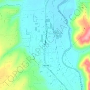
Name: Topografische Karte Darby, Höhe, Relief.
Ort: Darby, Ravalli County, Montana, United States (46.01387 -114.18807 46.03207 -114.17181)
Durchschnittliche Höhe: 1’210 m
Minimale Höhe: 1’174 m
Maximale Höhe: 1’316 m
Spenden
Rüste dich für dein nächstes Abenteuer:
Als Amazon-Partner verdient diese Seite an qualifizierten Käufen, ohne dass Ihnen zusätzliche Kosten entstehen.
Andere topografische Karten
Klicken Sie auf eine Karte, um ihre Topografie, ihre Höhe und ihr Relief anzuzeigen.
Bitterroot Range
United States > Montana > Ravalli County
The site of Brower's Spring is at about 8,800 feet (2,680 m) in elevation in the Centennials. The site is now commemorated by a rock cairn at the source of Hellroaring Creek, which flows into the Red Rock River and then into Clark canyon reservoir, where it joins the Beaverhead River and then the Big Hole…
Durchschnittliche Höhe: 2’112 m