
Topografische Karte Amritsar
Interaktive Karte
Klicken Sie auf die Karte, um die Höhe anzuzeigen.
Über diese Karte
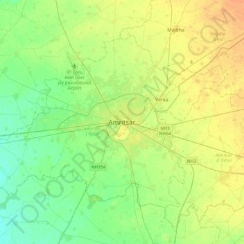
Name: Topografische Karte Amritsar, Höhe, Relief.
Durchschnittliche Höhe: 230 m
Minimale Höhe: 219 m
Maximale Höhe: 244 m
Amritsar is located at 31°38′N 74°52′E / 31.63°N 74.87°E / 31.63; 74.87 with an average elevation of 234 metres (768 ft). Amritsar is located in the Majha region of the state of Punjab in North India lies about 15 miles (25 km) east of the border with Pakistan. Administrative towns includes Ajnala, Attari, Beas, Budha Theh, Chheharta Sahib, Jandiala Guru, Majitha, Rajasansi, Ramdass, Rayya, Verka Town and Baba Bakala.