
Topografische Karte Pine Forest Range Wilderness Area
Interaktive Karte
Klicken Sie auf die Karte, um die Höhe anzuzeigen.
Über diese Karte
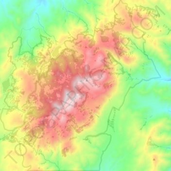
Name: Topografische Karte Pine Forest Range Wilderness Area, Höhe, Relief.
Durchschnittliche Höhe: 2’083 m
Minimale Höhe: 1’508 m
Maximale Höhe: 2’855 m
Andere topografische Karten
Klicken Sie auf eine Karte, um ihre Topografie, ihre Höhe und ihr Relief anzuzeigen.
Sonoma Valley
United States > Nevada > Humboldt County
Sonoma Valley, Humboldt County, Nevada, United States
Durchschnittliche Höhe: 2’052 m
Paradise Valley
United States > Nevada > Humboldt County
Paradise Valley, Humboldt County, Nevada, 89426, United States
Durchschnittliche Höhe: 1’387 m
Golconda
United States > Nevada > Humboldt County
Golconda, Humboldt County, Nevada, 89414, United States
Durchschnittliche Höhe: 1’352 m
Winnemucca
United States > Nevada > Humboldt County
Winnemucca, Humboldt County, Nevada, 89445, United States
Durchschnittliche Höhe: 1’365 m
Winnemucca
United States > Nevada > Humboldt County > Winnemucca > Winnemucca
Winnemucca, Humboldt County, Nevada, 89445, United States
Durchschnittliche Höhe: 1’403 m