
Topografische Karte Ponchou-Meïn
Interaktive Karte
Klicken Sie auf die Karte, um die Höhe anzuzeigen.
Über diese Karte
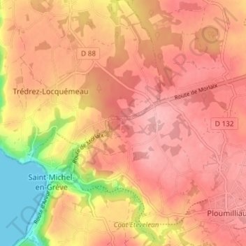
Name: Topografische Karte Ponchou-Meïn, Höhe, Relief.
Durchschnittliche Höhe: 85 m
Minimale Höhe: 0 m
Maximale Höhe: 124 m
Andere topografische Karten
Klicken Sie auf eine Karte, um ihre Topografie, ihre Höhe und ihr Relief anzuzeigen.
Lann Kerallic
France > Bretagne > Côtes-d'Armor > Ploumilliau
Lann Kerallic, Ploumilliau, Lannion, Côtes-d'Armor, Bretagne, France métropolitaine, 22300, France
Durchschnittliche Höhe: 56 m
Lotissement Tallegas
France > Bretagne > Côtes-d'Armor > Ploumilliau
Lotissement Tallegas, Ploumilliau, Lannion, Côtes-d'Armor, Bretagne, France métropolitaine, 22300, France
Durchschnittliche Höhe: 101 m
Pont Rous
France > Bretagne > Côtes-d'Armor > Ploumilliau
Pont Rous, Ploumilliau, Lannion, Côtes-d'Armor, Bretagne, France métropolitaine, 22300, France
Durchschnittliche Höhe: 57 m
Toull Karr
France > Bretagne > Côtes-d'Armor > Ploumilliau
Toull Karr, Ploumilliau, Lannion, Côtes-d'Armor, Bretagne, France métropolitaine, 22300, France
Durchschnittliche Höhe: 97 m