
Topografische Karte Avril
Interaktive Karte
Klicken Sie auf die Karte, um die Höhe anzuzeigen.
Über diese Karte
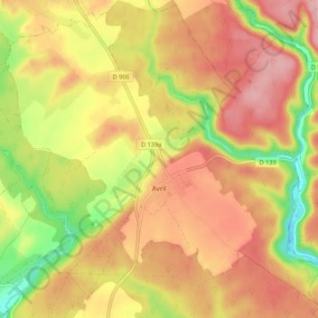
Name: Topografische Karte Avril, Höhe, Relief.
Durchschnittliche Höhe: 285 m
Minimale Höhe: 199 m
Maximale Höhe: 346 m
Andere topografische Karten
Klicken Sie auf eine Karte, um ihre Topografie, ihre Höhe und ihr Relief anzuzeigen.
Fontenoy-sur-Moselle
France > Grand Est > Meurthe-et-Moselle
Fontenoy-sur-Moselle, Toul, Meurthe-et-Moselle, Grand Est, France métropolitaine, 54840, France
Durchschnittliche Höhe: 226 m
Azelot
France > Grand Est > Meurthe-et-Moselle
Azelot, Nancy, Meurthe-et-Moselle, Grand Est, France métropolitaine, 54210, France
Durchschnittliche Höhe: 297 m
Bauzemont
France > Grand Est > Meurthe-et-Moselle
Bauzemont, Lunéville, Meurthe-et-Moselle, Grand Est, France métropolitaine, 54370, France
Durchschnittliche Höhe: 238 m
Moutiers
France > Grand Est > Meurthe-et-Moselle
Moutiers, Val-de-Briey, Meurthe-et-Moselle, Grand Est, France métropolitaine, 54660, France
Durchschnittliche Höhe: 239 m
Lay-Saint-Christophe
France > Grand Est > Meurthe-et-Moselle
Lay-Saint-Christophe, Nancy, Meurthe-et-Moselle, Grand Est, France métropolitaine, 54690, France
Durchschnittliche Höhe: 282 m
Laneuveville-devant-Bayon
France > Grand Est > Meurthe-et-Moselle
Laneuveville-devant-Bayon, Nancy, Meurthe-et-Moselle, Grand Est, France métropolitaine, 54740, France
Durchschnittliche Höhe: 319 m
Villers-lès-Nancy
France > Grand Est > Meurthe-et-Moselle
Villers-lès-Nancy, Nancy, Meurthe-et-Moselle, Grand Est, France métropolitaine, 54600, France
Durchschnittliche Höhe: 307 m
Cirey-sur-Vezouze
France > Grand Est > Meurthe-et-Moselle
Cirey-sur-Vezouze, Lunéville, Meurthe-et-Moselle, Grand Est, France métropolitaine, 54480, France
Durchschnittliche Höhe: 326 m
Noërs
France > Grand Est > Meurthe-et-Moselle > Longuyon
Noërs, Longuyon, Val-de-Briey, Meurthe-et-Moselle, Grand Est, France métropolitaine, 54260, France
Durchschnittliche Höhe: 266 m
Saint-Nicolas-de-Port
France > Grand Est > Meurthe-et-Moselle
Saint-Nicolas-de-Port, Nancy, Meurthe-et-Moselle, Grand Est, France métropolitaine, 54210, France
Durchschnittliche Höhe: 240 m
Saint-Clément
France > Grand Est > Meurthe-et-Moselle
Saint-Clément, Lunéville, Meurthe-et-Moselle, Grand Est, France métropolitaine, 54950, France
Durchschnittliche Höhe: 259 m
Allain
France > Grand Est > Meurthe-et-Moselle
Allain, Toul, Meurthe-et-Moselle, Grand Est, France métropolitaine, 54170, France
Durchschnittliche Höhe: 312 m
Franconville
France > Grand Est > Meurthe-et-Moselle
Franconville, Lunéville, Meurthe-et-Moselle, Grand Est, France métropolitaine, 54830, France
Durchschnittliche Höhe: 256 m
Longuyon
France > Grand Est > Meurthe-et-Moselle
Longuyon, Val-de-Briey, Meurthe-et-Moselle, Grand Est, France métropolitaine, 54260, France
Durchschnittliche Höhe: 297 m
Saulnes
France > Grand Est > Meurthe-et-Moselle
Saulnes, Val-de-Briey, Meurthe-et-Moselle, Grand Est, France métropolitaine, 54650, France
Durchschnittliche Höhe: 338 m
Baslieux
France > Grand Est > Meurthe-et-Moselle
Baslieux, Briey, Meurthe-et-Moselle, Grand Est, France métropolitaine, 54620, France
Durchschnittliche Höhe: 337 m
Frouard
France > Grand Est > Meurthe-et-Moselle
Frouard, Nancy, Meurthe-et-Moselle, Grand Est, France métropolitaine, 54390, France
Durchschnittliche Höhe: 281 m
Laneuveville-devant-Nancy
France > Grand Est > Meurthe-et-Moselle
Laneuveville-devant-Nancy, Nancy, Meurthe-et-Moselle, Grand Est, France métropolitaine, 54410, France
Durchschnittliche Höhe: 220 m
Fillières
France > Grand Est > Meurthe-et-Moselle
Fillières, Briey, Meurthe-et-Moselle, Grand Est, France métropolitaine, 54560, France
Durchschnittliche Höhe: 361 m
Briey
France > Grand Est > Meurthe-et-Moselle > Val de Briey
Briey, Val de Briey, Val-de-Briey, Meurthe-et-Moselle, Grand Est, France métropolitaine, 54150, France
Durchschnittliche Höhe: 262 m
Tiercelet
France > Grand Est > Meurthe-et-Moselle > Tiercelet
Tiercelet, Briey, Meurthe-et-Moselle, Grand Est, France métropolitaine, 54190, France
Durchschnittliche Höhe: 414 m
Courcelles
France > Grand Est > Meurthe-et-Moselle
Courcelles, Toul, Meurthe-et-Moselle, Grand Est, France métropolitaine, 54930, France
Durchschnittliche Höhe: 338 m
Villers-la-Montagne
France > Grand Est > Meurthe-et-Moselle > Villers-la-Montagne
Villers-la-Montagne, Briey, Meurthe-et-Moselle, Grand Est, France métropolitaine, 54920, France
Durchschnittliche Höhe: 378 m
Pont-à-Mousson
France > Grand Est > Meurthe-et-Moselle
Pont-à-Mousson, Nancy, Meurthe-et-Moselle, Grand Est, France métropolitaine, 54700, France
Durchschnittliche Höhe: 234 m
Audun-le-Roman
France > Grand Est > Meurthe-et-Moselle > Audun-le-Roman
Audun-le-Roman, Briey, Meurthe-et-Moselle, Grand Est, France métropolitaine, 54560, France
Durchschnittliche Höhe: 350 m
Malzéville
France > Grand Est > Meurthe-et-Moselle
Malzéville, Nancy, Meurthe-et-Moselle, Grand Est, France métropolitaine, 54220, France
Durchschnittliche Höhe: 258 m
Ugny
France > Grand Est > Meurthe-et-Moselle > Ugny
Ugny, Briey, Meurthe-et-Moselle, Grand Est, France métropolitaine, 54870, France
Durchschnittliche Höhe: 306 m
Longwy
France > Grand Est > Meurthe-et-Moselle
Longwy, Briey, Meurthe-et-Moselle, Grand Est, France métropolitaine, 54400, France
Durchschnittliche Höhe: 332 m
Nancy
France > Grand Est > Meurthe-et-Moselle
Nancy, Meurthe-et-Moselle, Grand Est, France métropolitaine, France
Durchschnittliche Höhe: 230 m
Bruly
France > Grand Est > Meurthe-et-Moselle > Bouvron > Ferme de la Charmotte
Bruly, Ferme de la Charmotte, Bouvron, Toul, Meurthe-et-Moselle, Grand Est, France métropolitaine, 54200, France
Durchschnittliche Höhe: 220 m
Moyen
France > Grand Est > Meurthe-et-Moselle
Moyen, Lunéville, Meurthe-et-Moselle, Grand Est, France métropolitaine, 54118, France
Durchschnittliche Höhe: 279 m
Bayon
France > Grand Est > Meurthe-et-Moselle
Bayon, Lunéville, Meurthe-et-Moselle, Grand Est, France métropolitaine, 54290, France
Durchschnittliche Höhe: 280 m
Champenoux
France > Grand Est > Meurthe-et-Moselle > Champenoux
Champenoux, Nancy, Meurthe-et-Moselle, Grand Est, France métropolitaine, 54280, France
Durchschnittliche Höhe: 245 m
Serres
France > Grand Est > Meurthe-et-Moselle > Serres
Serres, Lunéville, Meurthe-et-Moselle, Grand Est, France métropolitaine, 54370, France
Durchschnittliche Höhe: 272 m
Saint-Germain
France > Grand Est > Meurthe-et-Moselle
Saint-Germain, Lunéville, Meurthe-et-Moselle, Grand Est, France métropolitaine, 54290, France
Durchschnittliche Höhe: 311 m
Toul
France > Grand Est > Meurthe-et-Moselle
Toul, Meurthe-et-Moselle, Grand Est, France métropolitaine, 54200, France
Durchschnittliche Höhe: 245 m
Faulx
France > Grand Est > Meurthe-et-Moselle
Faulx, Nancy, Meurthe-et-Moselle, Grand Est, France métropolitaine, 54760, France
Durchschnittliche Höhe: 328 m
Sivry
France > Grand Est > Meurthe-et-Moselle
Sivry, Nancy, Meurthe-et-Moselle, Grand Est, France métropolitaine, 54610, France
Durchschnittliche Höhe: 297 m
Mexy
France > Grand Est > Meurthe-et-Moselle
Mexy, Briey, Meurthe-et-Moselle, Grand Est, France métropolitaine, 54135, France
Durchschnittliche Höhe: 341 m
Lunéville
France > Grand Est > Meurthe-et-Moselle
Lunéville, Meurthe-et-Moselle, Grand Est, France métropolitaine, 54300, France
Durchschnittliche Höhe: 249 m