
Topografische Karte Dufftown
Interaktive Karte
Klicken Sie auf die Karte, um die Höhe anzuzeigen.
Über diese Karte
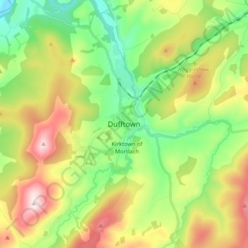
Name: Topografische Karte Dufftown, Höhe, Relief.
Ort: Dufftown, Moray, Scotland, AB55 4AD, United Kingdom (57.40490 -3.16835 57.48490 -3.08835)
Durchschnittliche Höhe: 268 m
Minimale Höhe: 79 m
Maximale Höhe: 567 m
Andere topografische Karten
Klicken Sie auf eine Karte, um ihre Topografie, ihre Höhe und ihr Relief anzuzeigen.
Glenlivet
United Kingdom > Scotland > Moray
Glenlivet, Moray, Scotland, AB37 9BT, United Kingdom
Durchschnittliche Höhe: 280 m
Spey Bay
United Kingdom > Scotland > Moray
Spey Bay, Moray, Scotland, IV32 7RR, United Kingdom
Durchschnittliche Höhe: 5 m
Longmorn
United Kingdom > Scotland > Moray > Longmorn
Longmorn, Moray, Scotland, IV30 8SA, United Kingdom
Durchschnittliche Höhe: 67 m
Dallas
United Kingdom > Scotland > Moray
Dallas, Moray, Scotland, IV36 2SA, United Kingdom
Durchschnittliche Höhe: 205 m
Ballindalloch
United Kingdom > Scotland > Moray > Ballindalloch
Ballindalloch, Moray, Scotland, AB37 9YF, United Kingdom
Durchschnittliche Höhe: 233 m
Forres
United Kingdom > Scotland > Moray > Forres
Forres, Moray, Scotland, IV36 1NX, United Kingdom
Durchschnittliche Höhe: 31 m
Kinloss
United Kingdom > Scotland > Moray
Kinloss, Moray, Scotland, IV36 3UT, United Kingdom
Durchschnittliche Höhe: 10 m