
Topografische Karte Rockingham
Interaktive Karte
Klicken Sie auf die Karte, um die Höhe anzuzeigen.
Über diese Karte
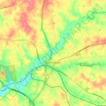
Name: Topografische Karte Rockingham, Höhe, Relief.
Ort: Rockingham, Richmond County, North Carolina, United States (34.90821 -79.79856 34.98381 -79.72818)
Durchschnittliche Höhe: 83 m
Minimale Höhe: 38 m
Maximale Höhe: 126 m
Andere topografische Karten
Klicken Sie auf eine Karte, um ihre Topografie, ihre Höhe und ihr Relief anzuzeigen.
Maplewood
United States > North Carolina > Richmond County > Rockingham > Maplewood
Maplewood, Rockingham, Richmond County, North Carolina, 28379, United States
Durchschnittliche Höhe: 83 m
Ellerbe
United States > North Carolina > Richmond County > Ellerbe
Ellerbe, Richmond County, North Carolina, United States
Durchschnittliche Höhe: 145 m
Leak Island
United States > North Carolina > Richmond County
Leak Island, Richmond County, North Carolina, 28007, United States
Durchschnittliche Höhe: 130 m