
Spenden
Rüste dich für dein nächstes Abenteuer:
Als Amazon-Partner verdient diese Seite an qualifizierten Käufen, ohne dass Ihnen zusätzliche Kosten entstehen.
Topografische Karte Bañón
Klicken Sie auf die Karte, um die Höhe anzuzeigen.
Spenden
Rüste dich für dein nächstes Abenteuer:
Als Amazon-Partner verdient diese Seite an qualifizierten Käufen, ohne dass Ihnen zusätzliche Kosten entstehen.
Bañón
El relieve del territorio está caracterizado por el ascenso oriental de la depresión del río Jiloca hacia el Sistema Ibérico turolense, por lo que la altitud es progresivamente más elevada de oeste a este. La altitud oscila por tanto entre los 1370 metros al sureste (Loma Pedriza) y los 970 metros al noroeste. El pueblo se alza a 1141 metros sobre el nivel del mar.
Spenden
Rüste dich für dein nächstes Abenteuer:
Als Amazon-Partner verdient diese Seite an qualifizierten Käufen, ohne dass Ihnen zusätzliche Kosten entstehen.
Über diese Karte
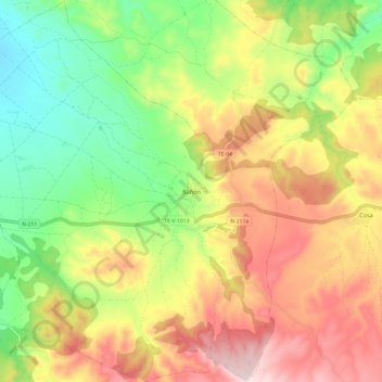
Name: Topografische Karte Bañón, Höhe, Relief.
Ort: Bañón, Jiloca, Teruel, Aragón, España (40.79396 -1.26316 40.88532 -1.16348)
Durchschnittliche Höhe: 1’159 m
Minimale Höhe: 968 m
Maximale Höhe: 1’378 m
Spenden
Rüste dich für dein nächstes Abenteuer:
Als Amazon-Partner verdient diese Seite an qualifizierten Käufen, ohne dass Ihnen zusätzliche Kosten entstehen.
Andere topografische Karten
Klicken Sie auf eine Karte, um ihre Topografie, ihre Höhe und ihr Relief anzuzeigen.