
Topografische Karte Banganga River
Interaktive Karte
Klicken Sie auf die Karte, um die Höhe anzuzeigen.
Über diese Karte
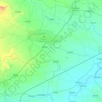
Name: Topografische Karte Banganga River, Höhe, Relief.
Ort: Banganga River, Nashik, Maharashtra, 422001, India (20.05074 73.83208 20.12001 74.04754)
Durchschnittliche Höhe: 584 m
Minimale Höhe: 532 m
Maximale Höhe: 810 m
Andere topografische Karten
Klicken Sie auf eine Karte, um ihre Topografie, ihre Höhe und ihr Relief anzuzeigen.
Raygad Udyan
India > Maharashtra > Nashik
Raygad Udyan, Nashik, Maharashtra, 422004, India
Durchschnittliche Höhe: 604 m
Pandav-Leni
India > Maharashtra > Nashik
Pandav-Leni, Nashik, Maharashtra, 422010, India
Durchschnittliche Höhe: 646 m
13
India > Maharashtra > Nashik > Pandav-Leni
13, Service Road, Ambad Gaon, Pandav-Leni, Nashik, Maharashtra, 422001, India
Durchschnittliche Höhe: 656 m
Nandur Madhyameshwar Dam
India > Maharashtra > Nashik
Nandur Madhyameshwar Dam, Nashik, Maharashtra, 422001, India
Durchschnittliche Höhe: 531 m
Shree Saptashrungi Udyan
India > Maharashtra > Nashik
Shree Saptashrungi Udyan, Nashik, Maharashtra, 422001, India
Durchschnittliche Höhe: 592 m