
Topografische Karte Bradley
Interaktive Karte
Klicken Sie auf die Karte, um die Höhe anzuzeigen.
Über diese Karte
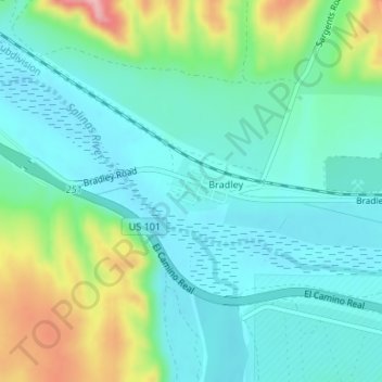
Name: Topografische Karte Bradley, Höhe, Relief.
Ort: Bradley, Monterey County, California, United States (35.86092 -120.80934 35.86462 -120.79867)
Durchschnittliche Höhe: 190 m
Minimale Höhe: 149 m
Maximale Höhe: 309 m
Bradley is an unincorporated community and census-designated place (CDP) in Monterey County, California, on the Salinas River 14 miles (23 km) south-southeast of San Ardo and 20 miles (32 km) north of Paso Robles. Bradley sits at an elevation of 548 feet (167 m). The population was 69 at the 2020 census, down from 93 at the 2010 census.
Andere topografische Karten
Klicken Sie auf eine Karte, um ihre Topografie, ihre Höhe und ihr Relief anzuzeigen.
Pebble Beach
United States > California > Monterey County > Del Monte Forest
Pebble Beach, Del Monte Forest, Monterey County, California, 93953, United States
Durchschnittliche Höhe: 53 m
Big Sur
United States > California > Monterey County
Big Sur, Monterey County, California, United States
Durchschnittliche Höhe: 313 m
Salinas
United States > California > Monterey County > Salinas
Salinas, Monterey County, California, United States
Durchschnittliche Höhe: 19 m