
Spenden
Rüste dich für dein nächstes Abenteuer:
Als Amazon-Partner verdient diese Seite an qualifizierten Käufen, ohne dass Ihnen zusätzliche Kosten entstehen.
Topografische Karte Mount Airy
Klicken Sie auf die Karte, um die Höhe anzuzeigen.
Spenden
Rüste dich für dein nächstes Abenteuer:
Als Amazon-Partner verdient diese Seite an qualifizierten Käufen, ohne dass Ihnen zusätzliche Kosten entstehen.
Mount Airy
The town was originally settled in the early 1830s by a core group of six families. Dorsey, Davis and Bussard were the most prominent names in that first settlement, which was followed closely by the construction of the B & O railroad line in 1831. Because Mount Airy sits at an elevation of 830 feet (250 m), a series of four inclined planes were constructed in order for the trains to climb the steep hills. Locomotives and cars were lifted with the assistance of horses and steam winches. Passengers had to disembark during this process. Plane #4, located west of the town at the intersection of Woodville Road and MD Route 144, is still a recognized location today. In 1839 the planes were abandoned, and the new line was constructed north of where Mount Airy is today. This was a result of more powerful locomotives that had been constructed and heavier loads were being hauled. In 1901, a railroad tunnel was constructed on the south side of town and the existing line into town became a spur line into the center of Mount Airy. The town named the first resident, Henry Bussard, the station agent for the new train station. Mr. Bussard was the first major landowner in Mount Airy.
Spenden
Rüste dich für dein nächstes Abenteuer:
Als Amazon-Partner verdient diese Seite an qualifizierten Käufen, ohne dass Ihnen zusätzliche Kosten entstehen.
Über diese Karte
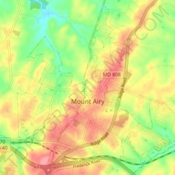
Name: Topografische Karte Mount Airy, Höhe, Relief.
Ort: Mount Airy, Carroll County, Maryland, United States (39.35936 -77.17936 39.40122 -77.11890)
Durchschnittliche Höhe: 221 m
Minimale Höhe: 169 m
Maximale Höhe: 269 m
Spenden
Rüste dich für dein nächstes Abenteuer:
Als Amazon-Partner verdient diese Seite an qualifizierten Käufen, ohne dass Ihnen zusätzliche Kosten entstehen.
Andere topografische Karten
Klicken Sie auf eine Karte, um ihre Topografie, ihre Höhe und ihr Relief anzuzeigen.
Belle Grove Square
United States > Maryland > Carroll County > Westminster
Durchschnittliche Höhe: 224 m
Spenden
Rüste dich für dein nächstes Abenteuer:
Als Amazon-Partner verdient diese Seite an qualifizierten Käufen, ohne dass Ihnen zusätzliche Kosten entstehen.
Piney Ridge Village
United States > Maryland > Carroll County > Eldersburg
Durchschnittliche Höhe: 182 m
Spenden
Rüste dich für dein nächstes Abenteuer:
Als Amazon-Partner verdient diese Seite an qualifizierten Käufen, ohne dass Ihnen zusätzliche Kosten entstehen.
Belle Grove Square
United States > Maryland > Carroll County > Westminster
Durchschnittliche Höhe: 224 m
Spenden
Rüste dich für dein nächstes Abenteuer:
Als Amazon-Partner verdient diese Seite an qualifizierten Käufen, ohne dass Ihnen zusätzliche Kosten entstehen.
Spenden
Rüste dich für dein nächstes Abenteuer:
Als Amazon-Partner verdient diese Seite an qualifizierten Käufen, ohne dass Ihnen zusätzliche Kosten entstehen.