Topografische Karte Etowah
Interaktive Karte
Klicken Sie auf die Karte, um die Höhe anzuzeigen.
Über diese Karte
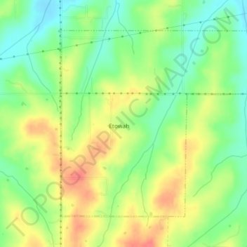
Name: Topografische Karte Etowah, Höhe, Relief.
Ort: Etowah, Cleveland County, Oklahoma, United States (35.11627 -97.17770 35.13833 -97.14199)
Durchschnittliche Höhe: 334 m
Minimale Höhe: 307 m
Maximale Höhe: 364 m
Andere topografische Karten
Klicken Sie auf eine Karte, um ihre Topografie, ihre Höhe und ihr Relief anzuzeigen.
Norman
United States > Oklahoma > Cleveland County
Norman, Cleveland County, Oklahoma, United States
Durchschnittliche Höhe: 358 m
Lexington
United States > Oklahoma > Cleveland County
Lexington, Cleveland County, Oklahoma, United States
Durchschnittliche Höhe: 321 m
Slaughterville
United States > Oklahoma > Cleveland County
Slaughterville, Cleveland County, Oklahoma, 73051, United States
Durchschnittliche Höhe: 344 m
Moore
United States > Oklahoma > Cleveland County
Moore, Cleveland County, Oklahoma, 73160, United States
Durchschnittliche Höhe: 373 m
Lake Thunderbird
United States > Oklahoma > Cleveland County > Norman
Lake Thunderbird, Norman, Cleveland County, Oklahoma, United States
Durchschnittliche Höhe: 334 m
Noble
United States > Oklahoma > Cleveland County
Noble, Cleveland County, Oklahoma, 73068, United States
Durchschnittliche Höhe: 344 m
SW Oklahoma City Sludge Lagoon Dam
United States > Oklahoma > Cleveland County > Oklahoma City
SW Oklahoma City Sludge Lagoon Dam, Oklahoma City, Cleveland County, Oklahoma, 73165, United States
Durchschnittliche Höhe: 348 m
Norman
United States > Oklahoma > Cleveland County > Norman
Norman, Cleveland County, Oklahoma, 73069, United States
Durchschnittliche Höhe: 356 m
Moore
United States > Oklahoma > Cleveland County > Moore > Moore
Moore, Cleveland County, Oklahoma, 73160, United States
Durchschnittliche Höhe: 377 m