
Topografische Karte Cooks
Interaktive Karte
Klicken Sie auf die Karte, um die Höhe anzuzeigen.
Über diese Karte
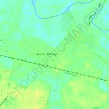
Name: Topografische Karte Cooks, Höhe, Relief.
Ort: Cooks, Montgomery County, Alabama, 36124, United States (32.39153 -86.16663 32.43153 -86.12663)
Durchschnittliche Höhe: 51 m
Minimale Höhe: 42 m
Maximale Höhe: 61 m
Andere topografische Karten
Klicken Sie auf eine Karte, um ihre Topografie, ihre Höhe und ihr Relief anzuzeigen.
Cloverland
United States > Alabama > Montgomery County > Montgomery
Cloverland, Montgomery, Montgomery County, Alabama, 36104, United States
Durchschnittliche Höhe: 67 m
Johnstown East
United States > Alabama > Montgomery County > Montgomery
Johnstown East, Montgomery, Montgomery County, Alabama, 36109, United States
Durchschnittliche Höhe: 73 m
Montgomery
United States > Alabama > Montgomery County
Montgomery, Montgomery County, Alabama, United States
Durchschnittliche Höhe: 64 m
Flatwood
United States > Alabama > Montgomery County
Flatwood, Montgomery County, Alabama, 36110, United States
Durchschnittliche Höhe: 49 m
Landmarks
United States > Alabama > Montgomery County > Montgomery > Landmarks
Landmarks, Montgomery, Montgomery County, Alabama, 36119, United States
Durchschnittliche Höhe: 72 m
Lapine
United States > Alabama > Montgomery County
Lapine, Montgomery County, Alabama, United States
Durchschnittliche Höhe: 139 m