
Topografische Karte Gilford
Interaktive Karte
Klicken Sie auf die Karte, um die Höhe anzuzeigen.
Über diese Karte
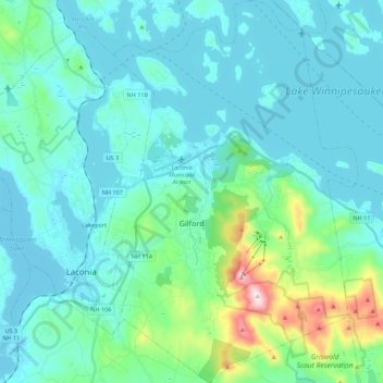
Name: Topografische Karte Gilford, Höhe, Relief.
Ort: Gilford, Belknap County, New Hampshire, 03249, United States (43.48157 -71.45817 43.64057 -71.31150)
Durchschnittliche Höhe: 231 m
Minimale Höhe: 146 m
Maximale Höhe: 720 m
According to the United States Census Bureau, the town has a total area of 53.6 square miles (138.7 km2), of which 38.8 sq mi (100.5 km2) are land and 14.7 sq mi (38.2 km2) are water, comprising 27.56% of the town. Belknap Mountain, elevation 2,384 feet (727 m) above sea level and the highest point in Gilford as well as Belknap County, is in the south. Much of the town is drained by the Gunstock River, a tributary of Lake Winnipesaukee. Gilford lies fully within the Merrimack River watershed.
Andere topografische Karten
Klicken Sie auf eine Karte, um ihre Topografie, ihre Höhe und ihr Relief anzuzeigen.
Lake Winnipesaukee
United States > New Hampshire > Belknap County > Alton
Lake Winnipesaukee, Alton, Belknap County, New Hampshire, 03226, United States
Durchschnittliche Höhe: 223 m
The Plains
United States > New Hampshire > Belknap County > Tilton
The Plains, Tilton, Belknap County, New Hampshire, 03252, United States
Durchschnittliche Höhe: 167 m
Mallard Cove
United States > New Hampshire > Belknap County > Laconia
Mallard Cove, Laconia, Belknap County, New Hampshire, 03246, United States
Durchschnittliche Höhe: 173 m
Sanbornton
United States > New Hampshire > Belknap County
Sanbornton, Belknap County, New Hampshire, 03269, United States
Durchschnittliche Höhe: 228 m
Tilton
United States > New Hampshire > Belknap County
Tilton, Belknap County, New Hampshire, United States
Durchschnittliche Höhe: 196 m
Meredith
United States > New Hampshire > Belknap County
Meredith, Belknap County, New Hampshire, 03253, United States
Durchschnittliche Höhe: 215 m
Barnstead
United States > New Hampshire > Belknap County
Barnstead, Belknap County, New Hampshire, United States
Durchschnittliche Höhe: 221 m