
Spenden
Rüste dich für dein nächstes Abenteuer:
Als Amazon-Partner verdient diese Seite an qualifizierten Käufen, ohne dass Ihnen zusätzliche Kosten entstehen.
Topografische Karte Little Sandy
Klicken Sie auf die Karte, um die Höhe anzuzeigen.
Spenden
Rüste dich für dein nächstes Abenteuer:
Als Amazon-Partner verdient diese Seite an qualifizierten Käufen, ohne dass Ihnen zusätzliche Kosten entstehen.
Über diese Karte
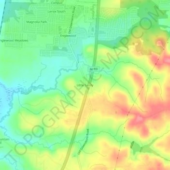
Name: Topografische Karte Little Sandy, Höhe, Relief.
Ort: Little Sandy, Tuscaloosa County, Alabama, United States (33.08012 -87.57501 33.12012 -87.53501)
Durchschnittliche Höhe: 72 m
Minimale Höhe: 34 m
Maximale Höhe: 122 m
Spenden
Rüste dich für dein nächstes Abenteuer:
Als Amazon-Partner verdient diese Seite an qualifizierten Käufen, ohne dass Ihnen zusätzliche Kosten entstehen.
Andere topografische Karten
Klicken Sie auf eine Karte, um ihre Topografie, ihre Höhe und ihr Relief anzuzeigen.
Tuscaloosa
United States > Alabama > Tuscaloosa County
The Tuscaloosa National Airport (KTCL) is 3.5 miles northwest of Tuscaloosa in Tuscaloosa County, Alabama. Owned and operated by the City of Tuscaloosa, the airport is an FAA-designated National General Aviation Airport and Part 139 Certified. Tuscaloosa National Airport covers 826 acres at an elevation of…
Durchschnittliche Höhe: 97 m
Spenden
Rüste dich für dein nächstes Abenteuer:
Als Amazon-Partner verdient diese Seite an qualifizierten Käufen, ohne dass Ihnen zusätzliche Kosten entstehen.