
Topografische Karte Solferino
Klicken Sie auf die Karte, um die Höhe anzuzeigen.
Solferino
Solferino liegt im Bereich der Endmoräne eines Seitenasts des eiszeitlichen Etschgletschers, die rund um das Südufer des vom Gletscher ausgeschürften Gardaseebeckens einen weiten Kranz gleichsam wie ein ausgedehntes, aber flaches Amphitheater mit Höhenunterschieden von bis zu 150 m bildet. Der markante Moränenhügel "La Rocca di Solferino", der den oben erwähnten "Spion von Italien" trägt, ist mit 206 m s.l.m. besonders bedeutsam.
Über diese Karte
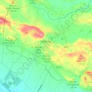
Name: Topografische Karte Solferino, Höhe, Relief.
Ort: Solferino, Mantua, Lombardei, 46040, Italien (45.34248 10.53443 45.38982 10.58191)
Durchschnittliche Höhe: 119 m
Minimale Höhe: 77 m
Maximale Höhe: 198 m
Andere topografische Karten
Klicken Sie auf eine Karte, um ihre Topografie, ihre Höhe und ihr Relief anzuzeigen.