
Topografische Karte Missouri Valley
Interaktive Karte
Klicken Sie auf die Karte, um die Höhe anzuzeigen.
Über diese Karte
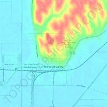
Name: Topografische Karte Missouri Valley, Höhe, Relief.
Ort: Missouri Valley, Harrison County, Iowa, 51555, United States (41.54281 -95.92891 41.57937 -95.87878)
Durchschnittliche Höhe: 321 m
Minimale Höhe: 301 m
Maximale Höhe: 384 m
Andere topografische Karten
Klicken Sie auf eine Karte, um ihre Topografie, ihre Höhe und ihr Relief anzuzeigen.
Logan
United States > Iowa > Harrison County
Logan, Harrison County, Iowa, 51546, United States
Durchschnittliche Höhe: 337 m
Magnolia
United States > Iowa > Harrison County
Magnolia, Harrison County, Iowa, 51550, United States
Durchschnittliche Höhe: 381 m
Persia
United States > Iowa > Harrison County
Persia, Harrison County, Iowa, United States
Durchschnittliche Höhe: 367 m
Mondamin
United States > Iowa > Harrison County
Mondamin, Harrison County, Iowa, United States
Durchschnittliche Höhe: 310 m
Modale
United States > Iowa > Harrison County
Modale, Harrison County, Iowa, United States
Durchschnittliche Höhe: 307 m
Yorkshire
United States > Iowa > Harrison County
Yorkshire, Harrison County, Iowa, United States
Durchschnittliche Höhe: 368 m
Dunlap
United States > Iowa > Harrison County
Dunlap, Harrison County, Iowa, 51529, United States
Durchschnittliche Höhe: 347 m
Woodbine
United States > Iowa > Harrison County
Woodbine, Harrison County, Iowa, United States
Durchschnittliche Höhe: 328 m
Little Sioux
United States > Iowa > Harrison County
Little Sioux, Harrison County, Iowa, United States
Durchschnittliche Höhe: 315 m
Pisgah
United States > Iowa > Harrison County
Pisgah, Harrison County, Iowa, United States
Durchschnittliche Höhe: 342 m