
Spenden
Rüste dich für dein nächstes Abenteuer:
Als Amazon-Partner verdient diese Seite an qualifizierten Käufen, ohne dass Ihnen zusätzliche Kosten entstehen.
Topografische Karte Keystone Lake
Klicken Sie auf die Karte, um die Höhe anzuzeigen.
Spenden
Rüste dich für dein nächstes Abenteuer:
Als Amazon-Partner verdient diese Seite an qualifizierten Käufen, ohne dass Ihnen zusätzliche Kosten entstehen.
Keystone Lake
The spillway is a gated ogee weir, 720 feet (220 m) wide with eighteen tainter gates, each 40 by 35 feet (12 by 11 m). Spillway capacity at the maximum pool level (elevation 766.0 feet (233.5 m)) is 939,000 cubic feet per second (26,600 m3/s). Capacity at the top of the flood control pool level (elevation 754.0 feet (229.8 m)) is 565,000 cubic feet per second (16,000 m3/s). The spillway also has nine sluices, each 5.67 by 10 feet (1.73 by 3.05 m).
Spenden
Rüste dich für dein nächstes Abenteuer:
Als Amazon-Partner verdient diese Seite an qualifizierten Käufen, ohne dass Ihnen zusätzliche Kosten entstehen.
Über diese Karte
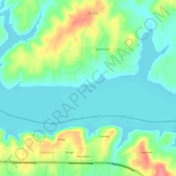
Name: Topografische Karte Keystone Lake, Höhe, Relief.
Durchschnittliche Höhe: 241 m
Minimale Höhe: 218 m
Maximale Höhe: 292 m
Spenden
Rüste dich für dein nächstes Abenteuer:
Als Amazon-Partner verdient diese Seite an qualifizierten Käufen, ohne dass Ihnen zusätzliche Kosten entstehen.