Geolokalisieren

Topografische Karte Fyfield

Klicken Sie auf die Karte, um die Höhe anzuzeigen.

Über diese Karte

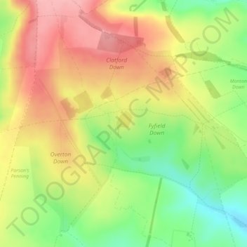
Name: Topografische Karte Fyfield, Höhe, Relief.

Ort: Fyfield, Wiltshire, England, United Kingdom, Wroughton Copse (51.43542 -1.80445 51.43829 -1.80181)

Durchschnittliche Höhe: 210 m

Minimale Höhe: 147 m

Maximale Höhe: 264 m

Andere topografische Karten

Klicken Sie auf eine Karte, um ihre Topografie, ihre Höhe und ihr Relief anzuzeigen.

Larkhill

United Kingdom > England > Wiltshire

Durchschnittliche Höhe: 111 m

Salisbury

United Kingdom > England > Wiltshire

Bishop of Salisbury Hubert Walter was instrumental in the negotiations with Saladin during the Third Crusade, but he spent little time in his diocese prior to his elevation to archbishop of Canterbury. The brothers Herbert and Richard Poore succeeded him and began planning the relocation of the cathedral into…

Durchschnittliche Höhe: 72 m

Stonehenge

United Kingdom > England > Wiltshire

Durchschnittliche Höhe: 99 m

Cley Hill

United Kingdom > England > Wiltshire

Cley Hill (grid reference ST838449) is a prominent hill to the west of Warminster in Wiltshire, England. Its summit has a commanding view of the Wiltshire / Somerset county boundary, at 244 metres (801 ft) elevation. The land is in Corsley parish and is owned by the National Trust.

Durchschnittliche Höhe: 157 m

Hurdcott

United Kingdom > England > Wiltshire > Winterbourne Earls

Durchschnittliche Höhe: 84 m

Warminster

United Kingdom > England > Wiltshire

Warminster Town Hall, at the junction of the High Street and Weymouth Street, was designed c. 1837 by Edward Blore at the expense of the 5th Marquess of Bath; the two-storey front elevation is a replica of Longleat, with the addition of a central bellcote, clock and coat of arms. The building was sold by the…

Durchschnittliche Höhe: 143 m

Rudloe

United Kingdom > England > Wiltshire

Durchschnittliche Höhe: 106 m

East Grafton

United Kingdom > England > Wiltshire

Durchschnittliche Höhe: 155 m

Rushall

United Kingdom > England > Wiltshire

Durchschnittliche Höhe: 140 m

Codford

United Kingdom > England > Wiltshire

Durchschnittliche Höhe: 126 m

Malmesbury

United Kingdom > England > Wiltshire

Malmesbury sits on a flat Cotswolds hilltop at the convergence of two rivers. The town has a maximum elevation of 146 metres (479 ft) and a minimum of 56 metres (184 ft); the average elevation is 92 metres (302 ft) above sea level. From the west, the infant (Bristol) Avon flows from Sherston, and from the…

Durchschnittliche Höhe: 84 m

Bulford

United Kingdom > England > Wiltshire

Durchschnittliche Höhe: 109 m

West Winterslow

United Kingdom > England > Wiltshire

Durchschnittliche Höhe: 115 m

Nunton

United Kingdom > England > Wiltshire

Durchschnittliche Höhe: 65 m

Thickwood

United Kingdom > England > Wiltshire > Colerne

Durchschnittliche Höhe: 123 m

Bishops Cannings

United Kingdom > England > Wiltshire

On the 27 May 1941, a Royal Air Force De Havilland Dragon Rapide (R5929) was operating a training flight out of RAF Yatesbury. The aircraft stalled at low altitude and crashed near the village, killing all seven on board.

Durchschnittliche Höhe: 154 m

Nomansland

United Kingdom > England > Wiltshire

Durchschnittliche Höhe: 68 m

Bishopstrow

United Kingdom > England > Wiltshire

Durchschnittliche Höhe: 148 m

Slaughterford

United Kingdom > England > Wiltshire

Durchschnittliche Höhe: 116 m

Horningsham

United Kingdom > England > Wiltshire

Durchschnittliche Höhe: 173 m

Yatton Keynell

United Kingdom > England > Wiltshire > Yatton Keynell

Durchschnittliche Höhe: 120 m

Hippenscombe

United Kingdom > England > Wiltshire

Durchschnittliche Höhe: 214 m

Chittoe Heath

United Kingdom > England > Wiltshire > Bromham

Durchschnittliche Höhe: 112 m

Christian Malford

United Kingdom > England > Wiltshire

Durchschnittliche Höhe: 63 m

West Overton

United Kingdom > England > Wiltshire > West Overton

Durchschnittliche Höhe: 186 m

Beechingstoke

United Kingdom > England > Wiltshire

Durchschnittliche Höhe: 111 m

Leigh Delamere

United Kingdom > England > Wiltshire

Durchschnittliche Höhe: 110 m

Corston

United Kingdom > England > Wiltshire

Durchschnittliche Höhe: 82 m

Longhedge

United Kingdom > England > Wiltshire > Corsley Heath

Durchschnittliche Höhe: 152 m

Tidworth

United Kingdom > England > Wiltshire

Durchschnittliche Höhe: 136 m

Ansty

United Kingdom > England > Wiltshire

Durchschnittliche Höhe: 158 m

North Bradley

United Kingdom > England > Wiltshire

Durchschnittliche Höhe: 50 m

Ashton Keynes

United Kingdom > England > Wiltshire

Durchschnittliche Höhe: 87 m

Lower Woodford

United Kingdom > England > Wiltshire

Durchschnittliche Höhe: 97 m

Wylye

United Kingdom > England > Wiltshire

Durchschnittliche Höhe: 129 m

Ford

United Kingdom > England > Wiltshire > North Wraxall

Durchschnittliche Höhe: 116 m

Steeple Langford

United Kingdom > England > Wiltshire

Durchschnittliche Höhe: 120 m

West Amesbury

United Kingdom > England > Wiltshire

Durchschnittliche Höhe: 90 m

Salisbury

United Kingdom > England > Wiltshire

Bishop of Salisbury Hubert Walter was instrumental in the negotiations with Saladin during the Third Crusade, but he spent little time in his diocese prior to his elevation to archbishop of Canterbury. The brothers Herbert and Richard Poore succeeded him and began planning the relocation of the cathedral into…

Durchschnittliche Höhe: 72 m

Westbury

United Kingdom > England > Wiltshire

Durchschnittliche Höhe: 105 m

Warminster

United Kingdom > England > Wiltshire

Warminster Town Hall, at the junction of the High Street and Weymouth Street, was designed c. 1837 by Edward Blore at the expense of the 5th Marquess of Bath; the two-storey front elevation is a replica of Longleat, with the addition of a central bellcote, clock and coat of arms. The building was sold by the…

Durchschnittliche Höhe: 143 m

Lyneham

United Kingdom > England > Wiltshire

Durchschnittliche Höhe: 116 m

Gastard

United Kingdom > England > Wiltshire

Durchschnittliche Höhe: 80 m

Hilmarton

United Kingdom > England > Wiltshire > Hilmarton

Durchschnittliche Höhe: 122 m

Salisbury

United Kingdom > England > Wiltshire

Bishop of Salisbury Hubert Walter was instrumental in the negotiations with Saladin during the Third Crusade, but he spent little time in his diocese prior to his elevation to archbishop of Canterbury. The brothers Herbert and Richard Poore succeeded him and began planning the relocation of the cathedral into…

Durchschnittliche Höhe: 72 m

West Kington

United Kingdom > England > Wiltshire

Durchschnittliche Höhe: 136 m

Heytesbury

United Kingdom > England > Wiltshire

Durchschnittliche Höhe: 146 m

Salisbury Canal

United Kingdom > England > Wiltshire > West Dean

Durchschnittliche Höhe: 74 m

Beversbrook

United Kingdom > England > Wiltshire > Calne

Durchschnittliche Höhe: 90 m

West Ashton

United Kingdom > England > Wiltshire > West Ashton

Durchschnittliche Höhe: 65 m

Ditteridge

United Kingdom > England > Wiltshire > Ashley

Durchschnittliche Höhe: 102 m

Roundway

United Kingdom > England > Wiltshire > Devizes

Durchschnittliche Höhe: 146 m

Tilshead

United Kingdom > England > Wiltshire

Durchschnittliche Höhe: 129 m

Lacock

United Kingdom > England > Wiltshire > Lacock

Durchschnittliche Höhe: 69 m

Box

United Kingdom > England > Wiltshire

Durchschnittliche Höhe: 113 m

Colerne

United Kingdom > England > Wiltshire

The name Colerne appears in the Domesday Book of 1086. Other early spellings include Culerna, Culerne, Cullerne, Collern. Various interpretations of the name have been proposed. Gover, Mawer and Stenton, in The Place Names of Wiltshire, cite a form aern meaning "house", and suggest that "col-aern might well…

Durchschnittliche Höhe: 128 m

Seend

United Kingdom > England > Wiltshire

Durchschnittliche Höhe: 53 m

Winsley

United Kingdom > England > Wiltshire > Winsley

Durchschnittliche Höhe: 95 m

Farley

United Kingdom > England > Wiltshire

Durchschnittliche Höhe: 81 m

Fonthill Gifford

United Kingdom > England > Wiltshire

Durchschnittliche Höhe: 152 m

Kington Langley

United Kingdom > England > Wiltshire

Durchschnittliche Höhe: 84 m

Great Somerford

United Kingdom > England > Wiltshire

Durchschnittliche Höhe: 69 m

Teffont Magna

United Kingdom > England > Wiltshire

Durchschnittliche Höhe: 123 m

Whitley

United Kingdom > England > Wiltshire

Durchschnittliche Höhe: 64 m

Stockton

United Kingdom > England > Wiltshire

Durchschnittliche Höhe: 134 m

Little Marsh

United Kingdom > England > Wiltshire > Semington

Durchschnittliche Höhe: 51 m

Stourton

United Kingdom > England > Wiltshire

Durchschnittliche Höhe: 174 m

Durrington

United Kingdom > England > Wiltshire

Durchschnittliche Höhe: 101 m

Turleigh

United Kingdom > England > Wiltshire > Winsley

Durchschnittliche Höhe: 85 m

Penknap

United Kingdom > England > Wiltshire > Westbury

Durchschnittliche Höhe: 96 m

Rodmead Hill

United Kingdom > England > Wiltshire

Durchschnittliche Höhe: 187 m

Heddington

United Kingdom > England > Wiltshire > Stockley

Durchschnittliche Höhe: 113 m

Winterslow

United Kingdom > England > Wiltshire

Durchschnittliche Höhe: 112 m

West Knoyle

United Kingdom > England > Wiltshire

Durchschnittliche Höhe: 168 m

Winkelbury Hill

United Kingdom > England > Wiltshire > Berwick St John

Durchschnittliche Höhe: 188 m

Bremhill

United Kingdom > England > Wiltshire > Bremhill

Durchschnittliche Höhe: 74 m

Dauntsey

United Kingdom > England > Wiltshire

Durchschnittliche Höhe: 67 m

Ashton Keynes

United Kingdom > England > Wiltshire

Durchschnittliche Höhe: 87 m

Potterne

United Kingdom > England > Wiltshire > Potterne

Durchschnittliche Höhe: 92 m

Salisbury

United Kingdom > England > Wiltshire

Bishop of Salisbury Hubert Walter was instrumental in the negotiations with Saladin during the Third Crusade, but he spent little time in his diocese prior to his elevation to archbishop of Canterbury. The brothers Herbert and Richard Poore succeeded him and began planning the relocation of the cathedral into…

Durchschnittliche Höhe: 72 m

West Overton

United Kingdom > England > Wiltshire > West Overton

Durchschnittliche Höhe: 186 m

Fosbury

United Kingdom > England > Wiltshire

Durchschnittliche Höhe: 190 m

Foxham

United Kingdom > England > Wiltshire

Durchschnittliche Höhe: 72 m

Landford

United Kingdom > England > Wiltshire

Durchschnittliche Höhe: 54 m

Sells Green

United Kingdom > England > Wiltshire > Seend

Durchschnittliche Höhe: 61 m

Chippenham

United Kingdom > England > Wiltshire

Durchschnittliche Höhe: 63 m

Sevington

United Kingdom > England > Wiltshire > Grittleton

Durchschnittliche Höhe: 117 m

Mount Sorrel

United Kingdom > England > Wiltshire > Broad Chalke

Durchschnittliche Höhe: 121 m

Sutton Mandeville

United Kingdom > England > Wiltshire

Durchschnittliche Höhe: 123 m

Coate

United Kingdom > England > Wiltshire > Bishops Cannings

Durchschnittliche Höhe: 133 m

Swallowcliffe Down

United Kingdom > England > Wiltshire > Ansty

Durchschnittliche Höhe: 157 m

Netherhampton

United Kingdom > England > Wiltshire > Quidhampton

Durchschnittliche Höhe: 73 m

Marston

United Kingdom > England > Wiltshire

Durchschnittliche Höhe: 59 m

Yatesbury

United Kingdom > England > Wiltshire

Durchschnittliche Höhe: 172 m

Odstock

United Kingdom > England > Wiltshire > Odstock

Durchschnittliche Höhe: 76 m

Roundway Down

United Kingdom > England > Wiltshire > Devizes

Durchschnittliche Höhe: 182 m

Ebbesborne Wake

United Kingdom > England > Wiltshire

Durchschnittliche Höhe: 154 m

Bulkington

United Kingdom > England > Wiltshire

Durchschnittliche Höhe: 49 m

Rüste dich für dein nächstes Abenteuer:

🔦Kopflampen für Outdoor - Helle und langlebige Lampen für Nacht‑ und Frühstarts
🧭Kompass & Navigationshilfen - Präzise Kompasse für Orientierung ohne GPS
🔦Campinglaternen - Rundum-Beleuchtung für das Zelt
🩹Blasenpflaster - Soforthilfe bei Druckstellen an den Füssen
🦶Orthopädische Einlegesohlen - Zusätzlicher Support für lange Tage auf steinigem Untergrund

Als Amazon-Partner verdient diese Seite an qualifizierten Käufen, ohne dass Ihnen zusätzliche Kosten entstehen.