
Topografische Karte St. Joseph
Interaktive Karte
Klicken Sie auf die Karte, um die Höhe anzuzeigen.
Über diese Karte
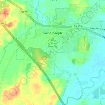
Name: Topografische Karte St. Joseph, Höhe, Relief.
Ort: St. Joseph, Stearns County, Minnesota, United States (45.52981 -94.34281 45.58023 -94.27561)
Durchschnittliche Höhe: 336 m
Minimale Höhe: 319 m
Maximale Höhe: 369 m
Andere topografische Karten
Klicken Sie auf eine Karte, um ihre Topografie, ihre Höhe und ihr Relief anzuzeigen.
Greenwald
United States > Minnesota > Stearns County
Greenwald, Stearns County, Minnesota, 56335, United States
Durchschnittliche Höhe: 386 m
Eden Valley
United States > Minnesota > Stearns County
Eden Valley, Stearns County, Minnesota, United States
Durchschnittliche Höhe: 346 m
St. Cloud
United States > Minnesota > Stearns County > St. Cloud
St. Cloud, Stearns County, Minnesota, United States
Durchschnittliche Höhe: 319 m
Paynesville
United States > Minnesota > Stearns County
Paynesville, Stearns County, Minnesota, United States
Durchschnittliche Höhe: 361 m