Geolokalisieren

Topografische Karte Platania

Interaktive Karte

Klicken Sie auf die Karte, um die Höhe anzuzeigen.

Über diese Karte

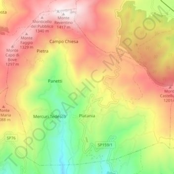
Name: Topografische Karte Platania, Höhe, Relief.

Ort: Platania, Catanzaro, Calabria, Italy (38.98840 16.28387 39.04209 16.36045)

Durchschnittliche Höhe: 865 m

Minimale Höhe: 305 m

Maximale Höhe: 1’402 m

Andere topografische Karten

Klicken Sie auf eine Karte, um ihre Topografie, ihre Höhe und ihr Relief anzuzeigen.

Germaneto

Italy > Calabria > Catanzaro > Catanzaro

Germaneto, Catanzaro, Calabria, 88100, Italy

Durchschnittliche Höhe: 136 m

Acconia

Italy > Calabria > Catanzaro

Acconia, Curinga, Catanzaro, Calabria, 88022, Italy

Durchschnittliche Höhe: 49 m

Acquamammone

Italy > Calabria > Catanzaro > Chiaravalle Centrale

Acquamammone, Chiaravalle Centrale, Catanzaro, Calabria, 88064, Italy

Durchschnittliche Höhe: 518 m

Santa Caterina dello Ionio

Italy > Calabria > Catanzaro > Santa Caterina dello Ionio

Santa Caterina dello Ionio, Catanzaro, Calabria, Italy

Durchschnittliche Höhe: 293 m

Sorbo San Basile

Italy > Calabria > Catanzaro

Sorbo San Basile, Catanzaro, Calabria, Italy

Durchschnittliche Höhe: 1’013 m