
Topografische Karte Kahlotus
Interaktive Karte
Klicken Sie auf die Karte, um die Höhe anzuzeigen.
Über diese Karte
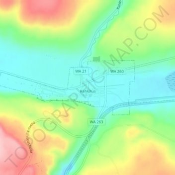
Name: Topografische Karte Kahlotus, Höhe, Relief.
Durchschnittliche Höhe: 327 m
Minimale Höhe: 259 m
Maximale Höhe: 433 m
Being located on the floor of a coulee puts Kahlotus at relatively lower elevation than the surrounding terrain. The steep walls of the coulee rise hundreds of feet dramatically to the north and south of the city center.
Andere topografische Karten
Klicken Sie auf eine Karte, um ihre Topografie, ihre Höhe und ihr Relief anzuzeigen.
Farrington
United States > Washington > Franklin County
Farrington, Franklin County, Washington, United States
Durchschnittliche Höhe: 294 m
Harder
United States > Washington > Franklin County
Harder, Franklin County, Washington, United States
Durchschnittliche Höhe: 350 m
West Pasco
United States > Washington > Franklin County
West Pasco, Franklin County, Washington, United States
Durchschnittliche Höhe: 119 m
Lower Monumental Dam
United States > Washington > Franklin County
Lower Monumental Dam, Franklin County, Washington, United States
Durchschnittliche Höhe: 230 m
Basin City
United States > Washington > Franklin County
Basin City, Franklin County, Washington, 99343, United States
Durchschnittliche Höhe: 221 m
Connell
United States > Washington > Franklin County
Connell, Franklin County, Washington, 99326, United States
Durchschnittliche Höhe: 312 m
Mesa
United States > Washington > Franklin County
Mesa, Franklin County, Washington, United States
Durchschnittliche Höhe: 239 m
Eltopia
United States > Washington > Franklin County
Eltopia, Franklin County, Washington, United States
Durchschnittliche Höhe: 211 m
Pasco
United States > Washington > Franklin County
Pasco, Franklin County, Washington, 99301, United States
Durchschnittliche Höhe: 141 m
Pasco
United States > Washington > Franklin County > Pasco
Pasco, Franklin County, Washington, United States
Durchschnittliche Höhe: 165 m