
Topografische Karte Sakib
Interaktive Karte
Klicken Sie auf die Karte, um die Höhe anzuzeigen.
Über diese Karte
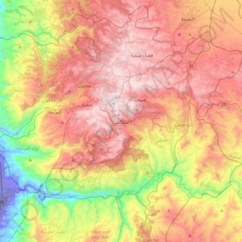
Name: Topografische Karte Sakib, Höhe, Relief.
Durchschnittliche Höhe: 639 m
Minimale Höhe: -254 m
Maximale Höhe: 1’244 m
Sakib is situated on the East Bank Plateau. Originally, the city had been built on Mountains. Sakib's terrain is typified by its mountains, and the area's elevation ranges from 900 to 1,200 m. Jerash is located to the east, Irbid io the north, Zarqa to the southeast and the capital Amman is to Sakib's south.
Andere topografische Karten
Klicken Sie auf eine Karte, um ihre Topografie, ihre Höhe und ihr Relief anzuzeigen.
الحداده
Jordan > Jarash > Jerash Sub-District > الحداده
الحداده, Jerash Sub-District, Qasabah Jerash, Jarash, 26111, Jordan
Durchschnittliche Höhe: 579 m