
Topografische Karte Middle Assendon
Klicken Sie auf die Karte, um die Höhe anzuzeigen.
Über diese Karte
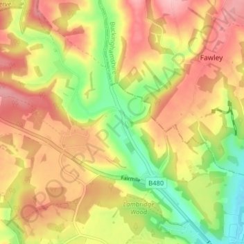
Name: Topografische Karte Middle Assendon, Höhe, Relief.
Durchschnittliche Höhe: 109 m
Minimale Höhe: 31 m
Maximale Höhe: 173 m
Andere topografische Karten
Klicken Sie auf eine Karte, um ihre Topografie, ihre Höhe und ihr Relief anzuzeigen.
Clifton Hampden
United Kingdom > England > Oxfordshire > South Oxfordshire > Clifton Hampden
Durchschnittliche Höhe: 58 m
Harpsden Wood
United Kingdom > England > Oxfordshire > South Oxfordshire > Henley-on-Thames > Harpsden
Durchschnittliche Höhe: 63 m
Watlington Hill
United Kingdom > England > Oxfordshire > South Oxfordshire > Watlington
Durchschnittliche Höhe: 189 m
Kingwood Common
United Kingdom > England > Oxfordshire > South Oxfordshire > Highmoor
Durchschnittliche Höhe: 125 m
Goring-on-Thames
United Kingdom > England > Oxfordshire > South Oxfordshire > Goring-on-Thames
Durchschnittliche Höhe: 87 m
Cowleaze Wood
United Kingdom > England > Oxfordshire > South Oxfordshire > Lewknor
Durchschnittliche Höhe: 209 m
Sonning Eye
United Kingdom > England > Oxfordshire > South Oxfordshire > Dunsden Green > Sonning Eye
Durchschnittliche Höhe: 44 m
Sandford-on-Thames
United Kingdom > England > Oxfordshire > South Oxfordshire
Durchschnittliche Höhe: 68 m
Swyncombe
United Kingdom > England > Oxfordshire > South Oxfordshire > Swyncombe
Durchschnittliche Höhe: 174 m
Britwell Salome
United Kingdom > England > Oxfordshire > South Oxfordshire
Durchschnittliche Höhe: 123 m
Aston Rowant Nature Reserve
United Kingdom > England > Oxfordshire > South Oxfordshire > Lewknor
Durchschnittliche Höhe: 192 m
Drayton St. Leonard
United Kingdom > England > Oxfordshire > South Oxfordshire
Durchschnittliche Höhe: 54 m
Brightwell-cum-Sotwell
United Kingdom > England > Oxfordshire > South Oxfordshire
Durchschnittliche Höhe: 54 m
Pill Pond
United Kingdom > England > Oxfordshire > South Oxfordshire > Didcot
Durchschnittliche Höhe: 71 m
Nuneham Courtenay
United Kingdom > England > Oxfordshire > South Oxfordshire
Durchschnittliche Höhe: 69 m
Little Wittenham
United Kingdom > England > Oxfordshire > South Oxfordshire
Durchschnittliche Höhe: 61 m
Kidmore End
United Kingdom > England > Oxfordshire > South Oxfordshire > Kidmore End
Durchschnittliche Höhe: 94 m
Horspath
United Kingdom > England > Oxfordshire > South Oxfordshire > Horspath
Durchschnittliche Höhe: 105 m
Berrick Salome
United Kingdom > England > Oxfordshire > South Oxfordshire
Durchschnittliche Höhe: 61 m
Chinnor Quarry 2B
United Kingdom > England > Oxfordshire > South Oxfordshire > Kingston Blount > Crowell
Durchschnittliche Höhe: 163 m
Whitchurch-on-Thames
United Kingdom > England > Oxfordshire > South Oxfordshire > Whitchurch-on-Thames
Durchschnittliche Höhe: 84 m
Edmonds Park
United Kingdom > England > Oxfordshire > South Oxfordshire > Didcot > East Hagbourne
Durchschnittliche Höhe: 68 m
Rotherfield Peppard
United Kingdom > England > Oxfordshire > South Oxfordshire > Rotherfield Peppard
Durchschnittliche Höhe: 115 m
Binfield Heath
United Kingdom > England > Oxfordshire > South Oxfordshire
Durchschnittliche Höhe: 73 m
Shirburn
United Kingdom > England > Oxfordshire > South Oxfordshire
Shirburn is a village and civil parish about 6 miles (10 km) south of Thame in Oxfordshire. It contains the Grade I listed, 14th-century Shirburn Castle, along with its surrounding, Grade II listed park, and a parish church, the oldest part of which is from the Norman period. The parish has a high altitude by…
Durchschnittliche Höhe: 140 m
East Hagbourne
United Kingdom > England > Oxfordshire > South Oxfordshire > East Hagbourne
Durchschnittliche Höhe: 62 m
Brightwell Baldwin
United Kingdom > England > Oxfordshire > South Oxfordshire > Cuxham
Durchschnittliche Höhe: 97 m
West Hagbourne
United Kingdom > England > Oxfordshire > South Oxfordshire
Durchschnittliche Höhe: 81 m
Sonning Common
United Kingdom > England > Oxfordshire > South Oxfordshire > Sonning Common
Durchschnittliche Höhe: 88 m
Long Wittenham
United Kingdom > England > Oxfordshire > South Oxfordshire
Durchschnittliche Höhe: 55 m
Stanton St John
United Kingdom > England > Oxfordshire > South Oxfordshire > Stanton St John
Durchschnittliche Höhe: 86 m
Warborough
United Kingdom > England > Oxfordshire > South Oxfordshire > Warborough
Durchschnittliche Höhe: 53 m
Clifton Hampden
United Kingdom > England > Oxfordshire > South Oxfordshire
Durchschnittliche Höhe: 58 m
Drayton St. Leonard
United Kingdom > England > Oxfordshire > South Oxfordshire
Durchschnittliche Höhe: 54 m
Holly Wood
United Kingdom > England > Oxfordshire > South Oxfordshire > Stanton St John
Durchschnittliche Höhe: 80 m