Geolokalisieren

Topografische Karte Srīnagar

Klicken Sie auf die Karte, um die Höhe anzuzeigen.

Über diese Karte

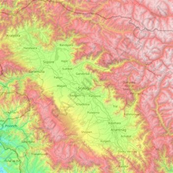
Name: Topografische Karte Srīnagar, Höhe, Relief.

Ort: Srīnagar, Srinagar, Jammu and Kashmir, 190003, India (33.38333 74.13333 34.78333 75.53333)

Durchschnittliche Höhe: 2’784 m

Minimale Höhe: 709 m

Maximale Höhe: 5’384 m

Andere topografische Karten

Klicken Sie auf eine Karte, um ihre Topografie, ihre Höhe und ihr Relief anzuzeigen.

Kupwara

India > Jammu and Kashmir

Durchschnittliche Höhe: 2’676 m

Uri

India > Jammu and Kashmir

Durchschnittliche Höhe: 2’144 m

Baramulla

India > Jammu and Kashmir

Durchschnittliche Höhe: 1’802 m

Doda

India > Jammu and Kashmir

Durchschnittliche Höhe: 2’212 m

Shopian

India > Jammu and Kashmir

Durchschnittliche Höhe: 2’033 m

Shangus tehsil

India > Jammu and Kashmir

Durchschnittliche Höhe: 2’451 m

Kokernag Tehsil

India > Jammu and Kashmir

Durchschnittliche Höhe: 2’646 m

Mansar Lake

India > Jammu and Kashmir > Majalta

Durchschnittliche Höhe: 654 m

Mendhar

India > Jammu and Kashmir

Durchschnittliche Höhe: 1’469 m

Atholi (Paddar)

India > Jammu and Kashmir

Durchschnittliche Höhe: 4’338 m

Samba

India > Jammu and Kashmir

Durchschnittliche Höhe: 462 m

Bhaderwah

India > Jammu and Kashmir

Durchschnittliche Höhe: 2’511 m

Reasi

India > Jammu and Kashmir

Durchschnittliche Höhe: 994 m

Bandipora

India > Jammu and Kashmir

Durchschnittliche Höhe: 2’703 m

Darhal

India > Jammu and Kashmir

Durchschnittliche Höhe: 1’991 m

Sopore

India > Jammu and Kashmir

Durchschnittliche Höhe: 1’683 m

Shopian

India > Jammu and Kashmir

Durchschnittliche Höhe: 2’525 m

Awantipora

India > Jammu and Kashmir

Durchschnittliche Höhe: 1’665 m

Kulgam

India > Jammu and Kashmir

Durchschnittliche Höhe: 1’818 m

Avantipora

India > Jammu and Kashmir > Awantipora

Durchschnittliche Höhe: 1’638 m

Batagund

India > Jammu and Kashmir > Tral

Durchschnittliche Höhe: 1’771 m

Tral

India > Jammu and Kashmir

Durchschnittliche Höhe: 2’528 m

Jhelum (Veth)

India > Jammu and Kashmir > Dooru tehsil > Vessu

Durchschnittliche Höhe: 1’658 m

Sundersar

India > Jammu and Kashmir > Pahalgam

Durchschnittliche Höhe: 3’989 m

Surinsar Lake

India > Jammu and Kashmir > Jammu

Durchschnittliche Höhe: 577 m

Rajouri

India > Jammu and Kashmir > Rajouri

Durchschnittliche Höhe: 963 m

Pampore

India > Jammu and Kashmir > Pampore

Durchschnittliche Höhe: 2’015 m

Chawalgam

India > Jammu and Kashmir > Kulgam

Durchschnittliche Höhe: 1’766 m

Marwah

India > Jammu and Kashmir

Durchschnittliche Höhe: 4’017 m

Banihal

India > Jammu and Kashmir

Durchschnittliche Höhe: 2’478 m

Anantnag district

India > Jammu and Kashmir

"Sir Walter Lawrence writes in his book The Valley of Kashmir that in latitude Kashmir corresponds with Peshawar, Baghdad and Damascus in Asia: with Fez in Morocco: and South Carolina in America, but it presents none of the characteristics of those countries. People have linked the climate of Kashmir to that…

Durchschnittliche Höhe: 2’830 m

Thathri

India > Jammu and Kashmir

Durchschnittliche Höhe: 2’057 m

Nillow

India > Jammu and Kashmir > Kulgam

Durchschnittliche Höhe: 1’824 m

Kangan

India > Jammu and Kashmir > Kangan

Durchschnittliche Höhe: 3’335 m

Kishtwar

India > Jammu and Kashmir

Durchschnittliche Höhe: 2’605 m

Kathua

India > Jammu and Kashmir

Durchschnittliche Höhe: 498 m

Ramban

India > Jammu and Kashmir

Durchschnittliche Höhe: 1’764 m

Udhampur

India > Jammu and Kashmir

Durchschnittliche Höhe: 1’292 m

Ganderbal

India > Jammu and Kashmir

Durchschnittliche Höhe: 1’885 m

Badgam tehsil

India > Jammu and Kashmir

Durchschnittliche Höhe: 1’644 m

Ranjit Sagar Dam

India > Jammu and Kashmir > Kathua

Durchschnittliche Höhe: 533 m

Lar

India > Jammu and Kashmir > Lar

Durchschnittliche Höhe: 2’024 m

Rajauri

India > Jammu and Kashmir

Durchschnittliche Höhe: 1’415 m

Bani

India > Jammu and Kashmir

Durchschnittliche Höhe: 2’300 m

Nowshehra Tehsil

India > Jammu and Kashmir > Nowshehra Tehsil

Durchschnittliche Höhe: 800 m

Rüste dich für dein nächstes Abenteuer:

🧭Outdoor-Kompasse - Klassische Orientierungshilfe für Kartenleser und Geografen
🧼Biologische Outdoor-Seife - Umweltfreundliche Hygiene in der Natur
🥣Camping‑Bestecksets - Leichte Bestecksets für Touren
🧭Analoge Höhenmesser - Zuverlässig ohne Batterien die Höhe bestimmen
🎒Kindertragen / Kraxen - Die ganze Familie auf topografischen Entdeckungsreisen

Als Amazon-Partner verdient diese Seite an qualifizierten Käufen, ohne dass Ihnen zusätzliche Kosten entstehen.