
Topografische Karte The Municipal District of Wicklow
Interaktive Karte
Klicken Sie auf die Karte, um die Höhe anzuzeigen.
Über diese Karte
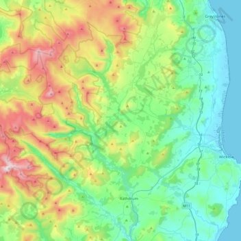
Name: Topografische Karte The Municipal District of Wicklow, Höhe, Relief.
Durchschnittliche Höhe: 263 m
Minimale Höhe: -1 m
Maximale Höhe: 925 m
Andere topografische Karten
Klicken Sie auf eine Karte, um ihre Topografie, ihre Höhe und ihr Relief anzuzeigen.
Lower Lough Bray
Lower Lough Bray, Powerscourt ED, The Municipal District of Bray, County Wicklow, Leinster, Irland
Durchschnittliche Höhe: 455 m
Eagle's Crag
Eagle's Crag, Powerscourt ED, The Municipal District of Bray, County Wicklow, Leinster, Irland
Durchschnittliche Höhe: 490 m