
Spenden
Rüste dich für dein nächstes Abenteuer:
Als Amazon-Partner verdient diese Seite an qualifizierten Käufen, ohne dass Ihnen zusätzliche Kosten entstehen.
Topografische Karte Conservation Area
Klicken Sie auf die Karte, um die Höhe anzuzeigen.
Spenden
Rüste dich für dein nächstes Abenteuer:
Als Amazon-Partner verdient diese Seite an qualifizierten Käufen, ohne dass Ihnen zusätzliche Kosten entstehen.
Über diese Karte
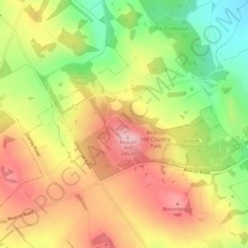
Name: Topografische Karte Conservation Area, Höhe, Relief.
Durchschnittliche Höhe: 168 m
Minimale Höhe: 75 m
Maximale Höhe: 247 m
Spenden
Rüste dich für dein nächstes Abenteuer:
Als Amazon-Partner verdient diese Seite an qualifizierten Käufen, ohne dass Ihnen zusätzliche Kosten entstehen.
Andere topografische Karten
Klicken Sie auf eine Karte, um ihre Topografie, ihre Höhe und ihr Relief anzuzeigen.
South Croxton
United Kingdom > England > Leicestershire > Charnwood > South Croxton
The highest point is the church, at 120 m above mean sea level. The lowest altitude is 85 m by the Queniborough Brook.
Durchschnittliche Höhe: 108 m
Spenden
Rüste dich für dein nächstes Abenteuer:
Als Amazon-Partner verdient diese Seite an qualifizierten Käufen, ohne dass Ihnen zusätzliche Kosten entstehen.
Queniborough
United Kingdom > England > Leicestershire > Charnwood > Queniborough
Durchschnittliche Höhe: 75 m
Barrow upon Soar
United Kingdom > England > Leicestershire > Charnwood > Barrow upon Soar
Durchschnittliche Höhe: 62 m
Shepshed
United Kingdom > England > Leicestershire > Charnwood > Shepshed
Durchschnittliche Höhe: 111 m
Spenden
Rüste dich für dein nächstes Abenteuer:
Als Amazon-Partner verdient diese Seite an qualifizierten Käufen, ohne dass Ihnen zusätzliche Kosten entstehen.
Mountsorrel
United Kingdom > England > Leicestershire > Charnwood > Mountsorrel
Durchschnittliche Höhe: 57 m
Spenden
Rüste dich für dein nächstes Abenteuer:
Als Amazon-Partner verdient diese Seite an qualifizierten Käufen, ohne dass Ihnen zusätzliche Kosten entstehen.
Charnwood Water
United Kingdom > England > Leicestershire > Charnwood > Woodthorpe
Durchschnittliche Höhe: 47 m
Thurmaston
United Kingdom > England > Leicestershire > Charnwood > Thurmaston
Durchschnittliche Höhe: 62 m
Spenden
Rüste dich für dein nächstes Abenteuer:
Als Amazon-Partner verdient diese Seite an qualifizierten Käufen, ohne dass Ihnen zusätzliche Kosten entstehen.
Lower Moor
United Kingdom > England > Leicestershire > Charnwood > Cossington
Durchschnittliche Höhe: 53 m
Old John
United Kingdom > England > Leicestershire > Charnwood > Newtown Linford
Durchschnittliche Höhe: 143 m
Spenden
Rüste dich für dein nächstes Abenteuer:
Als Amazon-Partner verdient diese Seite an qualifizierten Käufen, ohne dass Ihnen zusätzliche Kosten entstehen.
Six Hills
United Kingdom > England > Leicestershire > Charnwood > Burton on the Wolds
Durchschnittliche Höhe: 128 m
Ratcliffe on the Wreake
United Kingdom > England > Leicestershire > Charnwood
Durchschnittliche Höhe: 69 m
Spenden
Rüste dich für dein nächstes Abenteuer:
Als Amazon-Partner verdient diese Seite an qualifizierten Käufen, ohne dass Ihnen zusätzliche Kosten entstehen.
Swithland
United Kingdom > England > Leicestershire > Charnwood > Swithland
Durchschnittliche Höhe: 74 m
Burton on the Wolds
United Kingdom > England > Leicestershire > Charnwood
Durchschnittliche Höhe: 78 m
East Goscote
United Kingdom > England > Leicestershire > Charnwood > East Goscote
Durchschnittliche Höhe: 61 m
Spenden
Rüste dich für dein nächstes Abenteuer:
Als Amazon-Partner verdient diese Seite an qualifizierten Käufen, ohne dass Ihnen zusätzliche Kosten entstehen.
Cossington
United Kingdom > England > Leicestershire > Charnwood > Syston
Durchschnittliche Höhe: 61 m
Spenden
Rüste dich für dein nächstes Abenteuer:
Als Amazon-Partner verdient diese Seite an qualifizierten Käufen, ohne dass Ihnen zusätzliche Kosten entstehen.
Seagrave
United Kingdom > England > Leicestershire > Charnwood > Seagrave
Durchschnittliche Höhe: 98 m
Spenden
Rüste dich für dein nächstes Abenteuer:
Als Amazon-Partner verdient diese Seite an qualifizierten Käufen, ohne dass Ihnen zusätzliche Kosten entstehen.
Beeby
United Kingdom > England > Leicestershire > Charnwood
The physical and historical development of the hamlet has been strongly influenced by the local topography and its relative isolation. Beeby is situated within an established agricultural landscape largely in pastoral use. Until 1904 the east-west route was the only route through the hamlet, which was referred…
Durchschnittliche Höhe: 101 m
Barrow upon Soar
United Kingdom > England > Leicestershire > Charnwood > Barrow upon Soar
Durchschnittliche Höhe: 62 m
Spenden
Rüste dich für dein nächstes Abenteuer:
Als Amazon-Partner verdient diese Seite an qualifizierten Käufen, ohne dass Ihnen zusätzliche Kosten entstehen.
Thurmaston
United Kingdom > England > Leicestershire > Charnwood > Thurmaston
Durchschnittliche Höhe: 62 m
Spenden
Rüste dich für dein nächstes Abenteuer:
Als Amazon-Partner verdient diese Seite an qualifizierten Käufen, ohne dass Ihnen zusätzliche Kosten entstehen.
Cossington
United Kingdom > England > Leicestershire > Charnwood > Syston
Durchschnittliche Höhe: 61 m
Mammoth Lake
United Kingdom > England > Leicestershire > Charnwood > Thurmaston
Durchschnittliche Höhe: 58 m