
Vielen Dank für die Unterstützung dieser Website ❤️
Spenden
Spenden
Rüste dich für dein nächstes Abenteuer:
Als Amazon-Partner verdient diese Seite an qualifizierten Käufen, ohne dass Ihnen zusätzliche Kosten entstehen.
Topografische Karte Nagwadi
Klicken Sie auf die Karte, um die Höhe anzuzeigen.
Vielen Dank für die Unterstützung dieser Website ❤️
Spenden
Spenden
Rüste dich für dein nächstes Abenteuer:
Als Amazon-Partner verdient diese Seite an qualifizierten Käufen, ohne dass Ihnen zusätzliche Kosten entstehen.
Über diese Karte
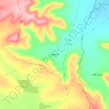
Name: Topografische Karte Nagwadi, Höhe, Relief.
Ort: Nagwadi, Pusad, Yavatmal District, Maharashtra, India (19.71413 77.57219 19.75413 77.61219)
Durchschnittliche Höhe: 427 m
Minimale Höhe: 344 m
Maximale Höhe: 522 m
Vielen Dank für die Unterstützung dieser Website ❤️
Spenden
Spenden
Rüste dich für dein nächstes Abenteuer:
Als Amazon-Partner verdient diese Seite an qualifizierten Käufen, ohne dass Ihnen zusätzliche Kosten entstehen.