
Topografische Karte Boulder
Interaktive Karte
Klicken Sie auf die Karte, um die Höhe anzuzeigen.
Über diese Karte
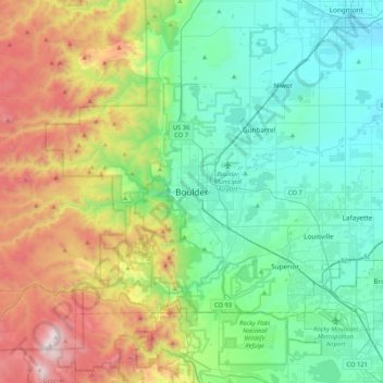
Name: Topografische Karte Boulder, Höhe, Relief.
Ort: Boulder, Boulder County, Colorado, 80306, United States (39.85499 -105.43055 40.17499 -105.11055)
Durchschnittliche Höhe: 1’977 m
Minimale Höhe: 1’495 m
Maximale Höhe: 3’187 m
Boulder is located at the base of the foothills of the Rocky Mountains, at an elevation of 5,430 feet (1,655 m) above sea level. Boulder is 25 miles (40 km) northwest of the Colorado State Capitol in Denver. It is home of the main campus of the University of Colorado, the state's largest university.
Andere topografische Karten
Klicken Sie auf eine Karte, um ihre Topografie, ihre Höhe und ihr Relief anzuzeigen.
Wonderland Lake
United States > Colorado > Boulder County > Boulder
Wonderland Lake, Boulder, Boulder County, Colorado, United States
Durchschnittliche Höhe: 1’739 m
Fredrick Law Olmsted, Jr. Park
United States > Colorado > Boulder County > Boulder
Fredrick Law Olmsted, Jr. Park, Washington Village, Boulder, Boulder County, Colorado, United States
Durchschnittliche Höhe: 1’664 m
Chautauqua Park
United States > Colorado > Boulder County > Boulder
Chautauqua Park, Boulder, Boulder County, Colorado, United States
Durchschnittliche Höhe: 1’774 m
University of Colorado Boulder (Williams Village)
United States > Colorado > Boulder County > Boulder
University of Colorado Boulder (Williams Village), Boulder, Boulder County, Colorado, United States
Durchschnittliche Höhe: 1’634 m
National Center for Atmospheric Research
United States > Colorado > Boulder County > Boulder
National Center for Atmospheric Research, Skunk Canyon Trail, Boulder, Boulder County, Colorado, 80310, United States
Durchschnittliche Höhe: 1’816 m
Seven Hills
United States > Colorado > Boulder County > Boulder > Seven Hills
Seven Hills, Boulder, Boulder County, Colorado, United States
Durchschnittliche Höhe: 1’985 m