
Spenden
Rüste dich für dein nächstes Abenteuer:
Als Amazon-Partner verdient diese Seite an qualifizierten Käufen, ohne dass Ihnen zusätzliche Kosten entstehen.
Topografische Karte Lake Placid
Klicken Sie auf die Karte, um die Höhe anzuzeigen.
Spenden
Rüste dich für dein nächstes Abenteuer:
Als Amazon-Partner verdient diese Seite an qualifizierten Käufen, ohne dass Ihnen zusätzliche Kosten entstehen.
Lake Placid
Lake Placid, located in Highlands County, Florida, is situated on relatively flat terrain characteristic of the Florida Peninsula. The town's average elevation is approximately 150 feet (46 meters) above sea level, with elevations ranging from a minimum of about 69 feet (21 meters) to a maximum of about 165 feet (50 meters). This gentle topography is typical of the region, contributing to the area's suitability for agriculture and outdoor recreational activities. The landscape is predominantly flat, with subtle undulations and low-lying areas, interspersed with numerous lakes and wetlands that enhance the area's natural beauty. The presence of these water bodies, such as Lake Placid itself, adds to the scenic charm and ecological diversity of the region.
Spenden
Rüste dich für dein nächstes Abenteuer:
Als Amazon-Partner verdient diese Seite an qualifizierten Käufen, ohne dass Ihnen zusätzliche Kosten entstehen.
Über diese Karte
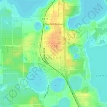
Name: Topografische Karte Lake Placid, Höhe, Relief.
Ort: Lake Placid, Highlands County, Florida, 33852, United States (27.27582 -81.39029 27.31301 -81.34960)
Durchschnittliche Höhe: 32 m
Minimale Höhe: 20 m
Maximale Höhe: 53 m
Spenden
Rüste dich für dein nächstes Abenteuer:
Als Amazon-Partner verdient diese Seite an qualifizierten Käufen, ohne dass Ihnen zusätzliche Kosten entstehen.
Andere topografische Karten
Klicken Sie auf eine Karte, um ihre Topografie, ihre Höhe und ihr Relief anzuzeigen.
Spenden
Rüste dich für dein nächstes Abenteuer:
Als Amazon-Partner verdient diese Seite an qualifizierten Käufen, ohne dass Ihnen zusätzliche Kosten entstehen.
Calvin Porter Park
United States > Florida > Highlands County > Avon Park
Durchschnittliche Höhe: 40 m
Spenden
Rüste dich für dein nächstes Abenteuer:
Als Amazon-Partner verdient diese Seite an qualifizierten Käufen, ohne dass Ihnen zusätzliche Kosten entstehen.