
Spenden
Rüste dich für dein nächstes Abenteuer:
Als Amazon-Partner verdient diese Seite an qualifizierten Käufen, ohne dass Ihnen zusätzliche Kosten entstehen.
Topografische Karte Ridge
Klicken Sie auf die Karte, um die Höhe anzuzeigen.
Spenden
Rüste dich für dein nächstes Abenteuer:
Als Amazon-Partner verdient diese Seite an qualifizierten Käufen, ohne dass Ihnen zusätzliche Kosten entstehen.
Über diese Karte
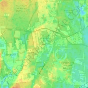
Name: Topografische Karte Ridge, Höhe, Relief.
Durchschnittliche Höhe: 27 m
Minimale Höhe: 10 m
Maximale Höhe: 48 m
Spenden
Rüste dich für dein nächstes Abenteuer:
Als Amazon-Partner verdient diese Seite an qualifizierten Käufen, ohne dass Ihnen zusätzliche Kosten entstehen.
Andere topografische Karten
Klicken Sie auf eine Karte, um ihre Topografie, ihre Höhe und ihr Relief anzuzeigen.
Fire Island
United States > New York > Suffolk County > Village of Bellport
Durchschnittliche Höhe: 9 m
Hampton Bays
United States > New York > Suffolk County > Town of Southampton
Durchschnittliche Höhe: 6 m
Spenden
Rüste dich für dein nächstes Abenteuer:
Als Amazon-Partner verdient diese Seite an qualifizierten Käufen, ohne dass Ihnen zusätzliche Kosten entstehen.
Town of East Hampton
United States > New York > Suffolk County
East Hampton is regularly hit by hurricanes and Nor'easters. Given the town's generally flat topography, water often accumulates on town roads stranding motorists in heavy rains.
Durchschnittliche Höhe: 3 m
East Setauket
United States > New York > Suffolk County > Town of Brookhaven > Setauket
Durchschnittliche Höhe: 40 m
Spenden
Rüste dich für dein nächstes Abenteuer:
Als Amazon-Partner verdient diese Seite an qualifizierten Käufen, ohne dass Ihnen zusätzliche Kosten entstehen.
Cold Spring Harbor
United States > New York > Suffolk County > Town of Huntington > Cold Spring Harbor
Durchschnittliche Höhe: 46 m
Spenden
Rüste dich für dein nächstes Abenteuer:
Als Amazon-Partner verdient diese Seite an qualifizierten Käufen, ohne dass Ihnen zusätzliche Kosten entstehen.
Halesite
United States > New York > Suffolk County > Town of Huntington > Halesite > Fort Hill
Durchschnittliche Höhe: 31 m
Spenden
Rüste dich für dein nächstes Abenteuer:
Als Amazon-Partner verdient diese Seite an qualifizierten Käufen, ohne dass Ihnen zusätzliche Kosten entstehen.
Melville
United States > New York > Suffolk County > Town of Huntington
Long Island's highest point is Jayne's Hill in the neighboring hamlet of West Hills, with an elevation of 387 feet (118 m) to 400.9 feet (122.2 m) above sea level.
Durchschnittliche Höhe: 53 m
Spenden
Rüste dich für dein nächstes Abenteuer:
Als Amazon-Partner verdient diese Seite an qualifizierten Käufen, ohne dass Ihnen zusätzliche Kosten entstehen.
North Bellport
United States > New York > Suffolk County > North Bellport
Durchschnittliche Höhe: 17 m
Manorville
United States > New York > Suffolk County > Town of Brookhaven
Manorville is in the center of Long Island with no access to the water. It lies partially on the Ronkonkoma terminal moraine, which creates some slightly rolling topography, especially in the central portion of the hamlet. The glacial topography of the area features several kettle hole ponds, the most…
Durchschnittliche Höhe: 22 m
Rocky Point
United States > New York > Suffolk County > Town of Brookhaven
Durchschnittliche Höhe: 31 m
Spenden
Rüste dich für dein nächstes Abenteuer:
Als Amazon-Partner verdient diese Seite an qualifizierten Käufen, ohne dass Ihnen zusätzliche Kosten entstehen.
Spenden
Rüste dich für dein nächstes Abenteuer:
Als Amazon-Partner verdient diese Seite an qualifizierten Käufen, ohne dass Ihnen zusätzliche Kosten entstehen.
Village of Port Jefferson
United States > New York > Suffolk County
In 1836 the local leadership initiated the community's transition from a "swampish hamlet" to a busy port town. The 22 acres of the harborfront, which flooded at high tide, were brought to a stable elevation with the construction of a causeway. The village changed its name from "Drowned Meadow" to "Port…
Durchschnittliche Höhe: 33 m
Central Islip
United States > New York > Suffolk County > Town of Islip > North Great River
Durchschnittliche Höhe: 20 m
Spenden
Rüste dich für dein nächstes Abenteuer:
Als Amazon-Partner verdient diese Seite an qualifizierten Käufen, ohne dass Ihnen zusätzliche Kosten entstehen.
Westhampton
United States > New York > Suffolk County > Town of Southampton
Durchschnittliche Höhe: 11 m
Village of Quogue
United States > New York > Suffolk County > Town of Southampton
Durchschnittliche Höhe: 5 m
Spenden
Rüste dich für dein nächstes Abenteuer:
Als Amazon-Partner verdient diese Seite an qualifizierten Käufen, ohne dass Ihnen zusätzliche Kosten entstehen.
Spenden
Rüste dich für dein nächstes Abenteuer:
Als Amazon-Partner verdient diese Seite an qualifizierten Käufen, ohne dass Ihnen zusätzliche Kosten entstehen.
Noyack
United States > New York > Suffolk County > Town of Southampton > Noyack
Durchschnittliche Höhe: 16 m
Fire Island
United States > New York > Suffolk County > Town of Brookhaven
Durchschnittliche Höhe: 9 m
Laurel
United States > New York > Suffolk County > Town of Southold > Laurel
Durchschnittliche Höhe: 7 m
Spenden
Rüste dich für dein nächstes Abenteuer:
Als Amazon-Partner verdient diese Seite an qualifizierten Käufen, ohne dass Ihnen zusätzliche Kosten entstehen.
Ronkonkoma
United States > New York > Suffolk County > Brentwood > Town of Islip
Durchschnittliche Höhe: 27 m
Spenden
Rüste dich für dein nächstes Abenteuer:
Als Amazon-Partner verdient diese Seite an qualifizierten Käufen, ohne dass Ihnen zusätzliche Kosten entstehen.
Islip Terrace
United States > New York > Suffolk County > Town of Islip > North Great River
Durchschnittliche Höhe: 11 m
Village of Old Field
United States > New York > Suffolk County > Town of Brookhaven
Durchschnittliche Höhe: 5 m
Spenden
Rüste dich für dein nächstes Abenteuer:
Als Amazon-Partner verdient diese Seite an qualifizierten Käufen, ohne dass Ihnen zusätzliche Kosten entstehen.
Wyandanch
United States > New York > Suffolk County > Wyandanch
The community was formerly known as Half Way Hollow Hills, West Deer Park (beginning in 1875), and Wyandance (in 1888). Topographically, Wyandanch's nutrient-poor loam and sandy soils are part of the outwash plain which was formed as the last glacier melted about 10,000 BCE. The outwash plain slopes gently…
Durchschnittliche Höhe: 21 m
Village of Lake Grove
United States > New York > Suffolk County > Town of Brookhaven
Durchschnittliche Höhe: 35 m
Setauket
United States > New York > Suffolk County > Town of Brookhaven > Setauket
Durchschnittliche Höhe: 14 m
Spenden
Rüste dich für dein nächstes Abenteuer:
Als Amazon-Partner verdient diese Seite an qualifizierten Käufen, ohne dass Ihnen zusätzliche Kosten entstehen.
Village of Nissequogue
United States > New York > Suffolk County > Town of Smithtown
Durchschnittliche Höhe: 19 m
Amagansett
United States > New York > Suffolk County > Town of East Hampton > Amagansett
Durchschnittliche Höhe: 10 m
Village of Shoreham
United States > New York > Suffolk County > Town of Brookhaven
Durchschnittliche Höhe: 33 m
Spenden
Rüste dich für dein nächstes Abenteuer:
Als Amazon-Partner verdient diese Seite an qualifizierten Käufen, ohne dass Ihnen zusätzliche Kosten entstehen.
Wading River
United States > New York > Suffolk County > Town of Riverhead
The earliest English records show a settlement known as Wading River was founded by eight colonial families. "The spot for the village was chosen with care. There was a stream adequate for water power and abounding in seafood...good water for drinking...soil rich enough to grow essential crops, woodland for…
Durchschnittliche Höhe: 23 m
Bohemia
United States > New York > Suffolk County > Town of Islip > North Great River
Durchschnittliche Höhe: 17 m
Spenden
Rüste dich für dein nächstes Abenteuer:
Als Amazon-Partner verdient diese Seite an qualifizierten Käufen, ohne dass Ihnen zusätzliche Kosten entstehen.
Huntington Station
United States > New York > Suffolk County > Huntington Station
Durchschnittliche Höhe: 61 m
Spenden
Rüste dich für dein nächstes Abenteuer:
Als Amazon-Partner verdient diese Seite an qualifizierten Käufen, ohne dass Ihnen zusätzliche Kosten entstehen.
Orient
United States > New York > Suffolk County > Town of Southold > Orient Point
Durchschnittliche Höhe: 1 m
Village of Greenport
United States > New York > Suffolk County > Town of Southold
Durchschnittliche Höhe: 3 m
West Hills County Park
United States > New York > Suffolk County > West Hills
Durchschnittliche Höhe: 79 m
Spenden
Rüste dich für dein nächstes Abenteuer:
Als Amazon-Partner verdient diese Seite an qualifizierten Käufen, ohne dass Ihnen zusätzliche Kosten entstehen.
Benjamin's Memorial Beach
United States > New York > Suffolk County > Bay Shore
Durchschnittliche Höhe: 2 m
Aquebogue
United States > New York > Suffolk County > Town of Riverhead > Aquebogue
Durchschnittliche Höhe: 8 m
Nesconset
United States > New York > Suffolk County > Town of Smithtown > Nesconset
Durchschnittliche Höhe: 31 m
Spenden
Rüste dich für dein nächstes Abenteuer:
Als Amazon-Partner verdient diese Seite an qualifizierten Käufen, ohne dass Ihnen zusätzliche Kosten entstehen.
East Northport
United States > New York > Suffolk County > East Northport
Durchschnittliche Höhe: 54 m
Spenden
Rüste dich für dein nächstes Abenteuer:
Als Amazon-Partner verdient diese Seite an qualifizierten Käufen, ohne dass Ihnen zusätzliche Kosten entstehen.
East Quogue
United States > New York > Suffolk County > Town of Southampton
Durchschnittliche Höhe: 11 m
East Quogue
United States > New York > Suffolk County > Town of Southampton
Durchschnittliche Höhe: 11 m
Spenden
Rüste dich für dein nächstes Abenteuer:
Als Amazon-Partner verdient diese Seite an qualifizierten Käufen, ohne dass Ihnen zusätzliche Kosten entstehen.
Northville
United States > New York > Suffolk County > Town of Riverhead > Northville
Durchschnittliche Höhe: 11 m
Spenden
Rüste dich für dein nächstes Abenteuer:
Als Amazon-Partner verdient diese Seite an qualifizierten Käufen, ohne dass Ihnen zusätzliche Kosten entstehen.
East Northport
United States > New York > Suffolk County > East Northport
Durchschnittliche Höhe: 54 m
Kings Park
United States > New York > Suffolk County > Town of Smithtown > Kings Park
Durchschnittliche Höhe: 32 m
Spenden
Rüste dich für dein nächstes Abenteuer:
Als Amazon-Partner verdient diese Seite an qualifizierten Käufen, ohne dass Ihnen zusätzliche Kosten entstehen.
Village of Head of the Harbor
United States > New York > Suffolk County > Town of Smithtown
Durchschnittliche Höhe: 35 m
Spenden
Rüste dich für dein nächstes Abenteuer:
Als Amazon-Partner verdient diese Seite an qualifizierten Käufen, ohne dass Ihnen zusätzliche Kosten entstehen.
West Bay Shore
United States > New York > Suffolk County > Town of Islip > West Bay Shore
Durchschnittliche Höhe: 3 m
Middle Island
United States > New York > Suffolk County > Middle Island
On October 27, 1910, the International Aviation Tournament was held at the Belmont Park racetrack in Elmont, New York. The meet offered $3,750 for the highest altitude, another $1,000 for a world record and a $5,000 bonus for exceeding 10,000 feet. Ralph Johnstone set a new American flight altitude record of…
Durchschnittliche Höhe: 31 m
Spenden
Rüste dich für dein nächstes Abenteuer:
Als Amazon-Partner verdient diese Seite an qualifizierten Käufen, ohne dass Ihnen zusätzliche Kosten entstehen.