
Topografische Karte Lockhart
Klicken Sie auf die Karte, um die Höhe anzuzeigen.
Über diese Karte
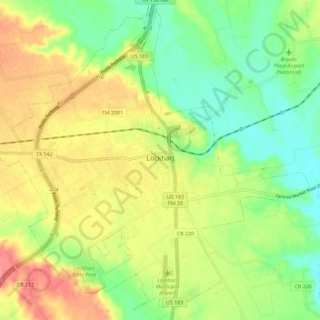
Name: Topografische Karte Lockhart, Höhe, Relief.
Ort: Lockhart, Caldwell County, Texas, 78644, United States (29.84064 -97.72832 29.92447 -97.62464)
Durchschnittliche Höhe: 156 m
Minimale Höhe: 125 m
Maximale Höhe: 193 m
Andere topografische Karten
Klicken Sie auf eine Karte, um ihre Topografie, ihre Höhe und ihr Relief anzuzeigen.
Lockhart State Park
United States > Texas > Caldwell County > Lockhart
The park features roughly four miles of designated trails that cover a wide range of environments. In addition to multiple short, shade covered trails along the creek in a riparian zone, a network of natural trails traversing multiple hillsides and ravines is located on the backside of the park. A moderate…
Durchschnittliche Höhe: 165 m