
Topografische Karte Bagnone
Interaktive Karte
Klicken Sie auf die Karte, um die Höhe anzuzeigen.
Über diese Karte
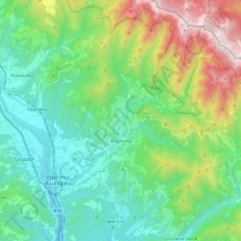
Name: Topografische Karte Bagnone, Höhe, Relief.
Durchschnittliche Höhe: 568 m
Minimale Höhe: 91 m
Maximale Höhe: 1’841 m
Bagnone is a comune (municipality) in the Province of Massa and Carrara in the Italian region Tuscany, located about 120 kilometres (75 mi) northwest of Florence and about 35 kilometres (22 mi) northwest of Massa in the Lunigiana, facing the Monte Sillara, which has a peak elevation of 1,861 metres (6,106 ft). The communal territory is crossed by the Bagnone torrent, a left affluence of the Magra River.