
Spenden
Rüste dich für dein nächstes Abenteuer:
Als Amazon-Partner verdient diese Seite an qualifizierten Käufen, ohne dass Ihnen zusätzliche Kosten entstehen.
Topografische Karte Taman Bukit Indah
Klicken Sie auf die Karte, um die Höhe anzuzeigen.
Spenden
Rüste dich für dein nächstes Abenteuer:
Als Amazon-Partner verdient diese Seite an qualifizierten Käufen, ohne dass Ihnen zusätzliche Kosten entstehen.
Über diese Karte
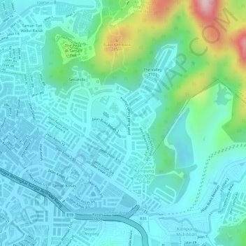
Name: Topografische Karte Taman Bukit Indah, Höhe, Relief.
Durchschnittliche Höhe: 104 m
Minimale Höhe: 52 m
Maximale Höhe: 311 m
Spenden
Rüste dich für dein nächstes Abenteuer:
Als Amazon-Partner verdient diese Seite an qualifizierten Käufen, ohne dass Ihnen zusätzliche Kosten entstehen.
Andere topografische Karten
Klicken Sie auf eine Karte, um ihre Topografie, ihre Höhe und ihr Relief anzuzeigen.
Kampung Indah Permai
Malaysia > Selangor > Ampang Jaya Municipal Council
Durchschnittliche Höhe: 137 m
Spenden
Rüste dich für dein nächstes Abenteuer:
Als Amazon-Partner verdient diese Seite an qualifizierten Käufen, ohne dass Ihnen zusätzliche Kosten entstehen.
Kampung Sri Taman Baru
Malaysia > Selangor > Ampang Jaya Municipal Council
Durchschnittliche Höhe: 109 m
Spenden
Rüste dich für dein nächstes Abenteuer:
Als Amazon-Partner verdient diese Seite an qualifizierten Käufen, ohne dass Ihnen zusätzliche Kosten entstehen.
Kampung Dato Mufti Shuib
Malaysia > Selangor > Ampang Jaya Municipal Council
Durchschnittliche Höhe: 118 m
Hulu Kelang
Malaysia > Selangor > Ampang Jaya Municipal Council
It has an area of 16.94 square kilometres, and is located northeast of Kuala Lumpur. The surface is relatively high; 500 metres above sea level, and the topography here is highland, lowland, or undulating land. As a result, it is a rain catchment area for the Klang River. Among the high locations are Bukit…
Durchschnittliche Höhe: 147 m
Air Terjun Empangan Tasik Hijau
Malaysia > Selangor > Ampang Jaya Municipal Council
Durchschnittliche Höhe: 184 m
Spenden
Rüste dich für dein nächstes Abenteuer:
Als Amazon-Partner verdient diese Seite an qualifizierten Käufen, ohne dass Ihnen zusätzliche Kosten entstehen.
Kampung Indah Permai
Malaysia > Selangor > Ampang Jaya Municipal Council
Durchschnittliche Höhe: 137 m
Kampung Tasik Tambahan
Malaysia > Selangor > Ampang Jaya Municipal Council
Durchschnittliche Höhe: 118 m
Kawasan Rekreasi AU2 Keramat
Malaysia > Selangor > Ampang Jaya Municipal Council
Durchschnittliche Höhe: 74 m
Spenden
Rüste dich für dein nächstes Abenteuer:
Als Amazon-Partner verdient diese Seite an qualifizierten Käufen, ohne dass Ihnen zusätzliche Kosten entstehen.